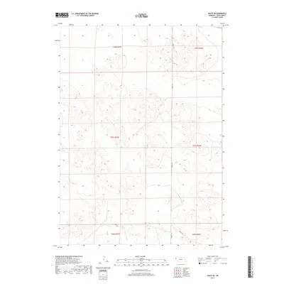
2017 Map of Agate SW
USGS Topo · Published 2017About this map
Sioux County's high plains terrain is defined here by the Public Land Survey System grids of T28N, T27N, and T26N. This 2017 survey by the U.S. Geological Survey documents a sparse but functional network of rural transportation routes that navigate the undulating topography of the Nebraska panhandle. Principal thoroughfares such as Morrill Rd and Murphy Rd provide the primary access through the sections, while smaller tracks like Moore Rd and Murphys Rd connect the isolated ranching and agricultural lands. The map illustrates a landscape of intermittent drainage patterns and subtle elevation shifts, characteristic of this part of the Sheep Creek Precinct. Given the limited density of named settlements, these established roads serve as the most critical landmarks for identifying property boundaries and historical land use in this expansive region.
Find a feature on this map
10 named features on this map. Tap any name to fly to it.
Don’t see what you’re looking for? This feature index may not catch every label — zoom into the map to look around manually.
Map Details
Editions of this 2017 Agate SW Map
This is the sole edition of this map. No revisions or reprints were ever made.
Other maps of this area

1896 · Patrick
USGS Topo · 1:125,000

1899 · Whistle Creek
USGS Topo · 1:125,000

1954 · Torrington
USGS Topo · 1:250,000

1955 · Alliance
USGS Topo · 1:250,000

1957 · Alliance
USGS Topo · 1:250,000

1958 · Torrington
USGS Topo · 1:250,000

1958 · Alliance
USGS Topo · 1:250,000

1963 · Chalk Buttes
USGS Topo · 1:24,000
1963 · Carpenter Ranch
USGS Topo · 1:24,000

1974 · Spoon Butte
USGS Topo · 1:24,000