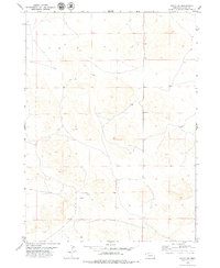
1979 Map of Agate SW
USGS Topo · Published 1979About this map
High plains ranching country in Sioux County, Nebraska, defines this landscape as it appeared in the late 1970s. The terrain is sparsely settled, marked primarily by the isolated Hilltop Sch and primitive Jeep Trail networks that crisscross the sections. Evidence of land use is found in scattered wells, a Spring, and exploratory sites like the Drill Hole in Section 15. The presence of a solitary Grave in Section 4 suggests the early settlement history and individual family legacy of this corner of the Nebraska panhandle. This survey records the exact township and range boundaries for T 28 N, T 27 N, and T 26 N, providing a precise topographic reference for the bench marks BM 4634 and BM 4507.
Find a feature on this map
11 named features on this map. Tap any name to fly to it.
Don’t see what you’re looking for? This feature index may not catch every label — zoom into the map to look around manually.
Map Details
Editions of this 1979 Agate SW Map
This is the sole edition of this map. No revisions or reprints were ever made.
Other maps of this area

1896 · Patrick
USGS Topo · 1:125,000

1899 · Whistle Creek
USGS Topo · 1:125,000

1954 · Torrington
USGS Topo · 1:250,000

1955 · Alliance
USGS Topo · 1:250,000

1957 · Alliance
USGS Topo · 1:250,000

1958 · Torrington
USGS Topo · 1:250,000

1958 · Alliance
USGS Topo · 1:250,000

1963 · Chalk Buttes
USGS Topo · 1:24,000
1963 · Carpenter Ranch
USGS Topo · 1:24,000

1974 · Spoon Butte
USGS Topo · 1:24,000