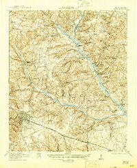
1921 Map of Aiken
USGS Topo · Published 1945About this map
The Aiken township and its surrounding rural network are documented here just after the First World War, revealing a landscape defined by its waterways and early educational centers. The South Fork Edisto River and its numerous tributaries, such as Little Branch and Shaw Fork, create a convoluted terrain of ponds and ridges that dictated early road placement. This survey provides a remarkable look at the density of community institutions in early twentieth-century South Carolina, featuring numerous rural schools like Fountain Academy and Ocean Grove School, alongside centers of worship such as Welcome Traveler Church and China Spring Church. Transportation is anchored by the Southern Railway and the Charleston and Western Carolina Railway, which connect the town center to smaller hubs like Montmorenci and Croft. Local industry is evidenced by the Livingstons Mill and the expansive Aiken Water Works system.
Find a feature on this map
77 named features on this map. Tap any name to fly to it.
Don’t see what you’re looking for? This feature index may not catch every label — zoom into the map to look around manually.
Map Details
Editions of this 1921 Aiken Map
3 editions found
Other maps of this area

1920 · Aiken
USGS Topo · 1:48,000

1920 · Talatha
USGS Topo · 1:48,000

1921 · Augusta
USGS Topo · 1:62,500

1921 · Aiken
USGS Topo · 1:62,500

1921 · Talatha
USGS Topo · 1:62,500

1923 · Williston
USGS Topo · 1:48,000

1923 · Warrenville
USGS Topo · 1:48,000

1927 · Williston
USGS Topo · 1:62,500

1928 · Warrenville
USGS Topo · 1:62,500

1943 · Aiken
USGS Topo · 1:62,500