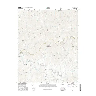
2016 Map of Alarka
USGS Topo · Published 2016About this map
The Little Tennessee River winds through the southern portion of this region, serving as a primary geographic anchor for the communities of Oak Grove and Stiles. This 2016 survey illustrates the complex topography of the Cowee Mountains and the Alarka Mountains, where high peaks like Phillip Knob and Blackrock Knob overlook the deeply carved valleys of Alarka Cr and Matlock Cr. The settlement patterns here are defined by these watercourses, with small population centers and family-named landmarks positioned along the narrow bottomlands.
Find a feature on this map
118 named features on this map. Tap any name to fly to it.
Don’t see what you’re looking for? This feature index may not catch every label — zoom into the map to look around manually.
Map Details
Editions of this 2016 Alarka Map
This is the sole edition of this map. No revisions or reprints were ever made.
Other maps of this area

1891 · Cowee
USGS Topo · 1:125,000

1897 · Cowee
USGS Topo · 1:125,000

1907 · Cowee
USGS Topo · 1:125,000

1933 · Bryson
USGS Topo · 1:62,500

1933 · Bushnell
USGS Topo · 1:62,500

1935 · Franklin
USGS Topo · 1:24,000

1935 · Burningtown Bald
USGS Topo · 1:24,000

1935 · Wayah Bald
USGS Topo · 1:48,000

1935 · Corbin Knob
USGS Topo · 1:24,000
1936 · Greens Creek
USGS Topo · 1:24,000