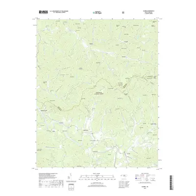
2019 Map of Alarka
USGS Topo · Published 2019About this map
The Little Tennessee River snakes through the southern portion of this region, defining the local geography with major bends such as Coggins Bend and Raby Bend. These river features provided natural locations for early settlement and river crossings, evidenced by the McCoy Bridge and the namesake Lost Bridge. Small communities such as Oak Grove, Stiles, and Cowee are situated along the valley floors, while the northern terrain rises into the Cowee Mountains and the protected lands of the Nantahala National Forest. Genealogists will find a wealth of family history in the numerous small burial grounds dispersed across the ridges and coves, including Davis Cem, Brendle Cem, and the Shepherd Cem. The map reveals a landscape where road 28 follows the old contours of the land, connecting isolated settlements like Leatherman and Alarka within the steep topography of the Swain Co and Macon Co boundary.
Find a feature on this map
121 named features on this map. Tap any name to fly to it.
Don’t see what you’re looking for? This feature index may not catch every label — zoom into the map to look around manually.
Map Details
Editions of this 2019 Alarka Map
This is the sole edition of this map. No revisions or reprints were ever made.
Other maps of this area

1891 · Cowee
USGS Topo · 1:125,000

1897 · Cowee
USGS Topo · 1:125,000

1907 · Cowee
USGS Topo · 1:125,000

1933 · Bryson
USGS Topo · 1:62,500

1933 · Bushnell
USGS Topo · 1:62,500

1935 · Franklin
USGS Topo · 1:24,000

1935 · Burningtown Bald
USGS Topo · 1:24,000

1935 · Wayah Bald
USGS Topo · 1:48,000

1935 · Corbin Knob
USGS Topo · 1:24,000
1936 · Greens Creek
USGS Topo · 1:24,000