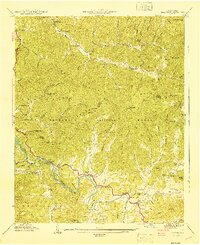
1941 Map of Alarka
USGS Topo · Published 1941About this map
Little Tennessee River winding through the Nantahala Mountains defines the geography of this early 1940s survey. The map documents a landscape of high summits and deep coves on the border of Swain and Macon counties. Small communities and family landmarks are concentrated along the watercourses, particularly near Alarka and the post offices at Etna and Wests Mill. Genealogy researchers will find numerous family-named burial sites including Morgan Cem, Cochran Cem, and Shepherd Cem. Infrastructure of the era is captured at Mc Coy Bridge and several local schools like Brush Creek Sch and White Oak Sch. The heavy contouring illustrates the steep rise from the riverbanks to peaks such as Pinnacle Knob and Blackrock Knob, much of which is contained within the Nantahala National Forest.
Find a feature on this map
102 named features on this map. Tap any name to fly to it.
Don’t see what you’re looking for? This feature index may not catch every label — zoom into the map to look around manually.
Map Details
Editions of this 1941 Alarka Map
This is the sole edition of this map. No revisions or reprints were ever made.
Other maps of this area

1891 · Cowee
USGS Topo · 1:125,000

1897 · Cowee
USGS Topo · 1:125,000

1907 · Cowee
USGS Topo · 1:125,000

1933 · Bryson
USGS Topo · 1:62,500

1933 · Bushnell
USGS Topo · 1:62,500

1935 · Franklin
USGS Topo · 1:24,000

1935 · Burningtown Bald
USGS Topo · 1:24,000

1935 · Wayah Bald
USGS Topo · 1:48,000

1935 · Corbin Knob
USGS Topo · 1:24,000
1936 · Greens Creek
USGS Topo · 1:24,000