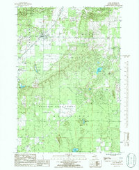
1985 Map of Alba
USGS Topo · Published 1986About this map
Alba serves as the primary settlement within this northern Michigan landscape, situated at the junction of the Chestonia, Star, and Mancelona townships. The map reveals a transition from the structured street grid of the village, which includes a local Cem., to the expansive wooded reaches of the Mackinaw State Forest. Transport history is etched into the terrain by an Old Railroad Grade that winds through the forest, now complemented by modern recreational additions like a Cycle Trail and a Landing Strip. A scattered network of glacial lakes, including Lake Harold, Wetzel Lake, and Hawk Lake, provides a natural contrast to industrial features like the multiple Gravel Pits found near the settlement. The inclusion of a Trailer Park & Campground reflects the area's development as a destination for outdoor recreation during the mid-1980s.
Find a feature on this map
21 named features on this map. Tap any name to fly to it.
Don’t see what you’re looking for? This feature index may not catch every label — zoom into the map to look around manually.
Map Details
Editions of this 1985 Alba Map
This is the sole edition of this map. No revisions or reprints were ever made.
Other maps of this area

1954 · Traverse City
USGS Topo · 1:250,000

1955 · Cheboygan
USGS Topo · 1:250,000

1956 · Alba
USGS Topo · 1:62,500

1956 · Mancelona
USGS Topo · 1:62,500

1958 · Cheboygan
USGS Topo · 1:250,000

1958 · Traverse City
USGS Topo · 1:250,000

1961 · Boyne Falls
USGS Topo · 1:62,500

1961 · Boyne City
USGS Topo · 1:62,500

1975 · Mancelona NE
USGS Topo · 1:24,000

1982 · Petoskey
USGS Topo · 1:100,000