
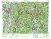
1956 Map of Albany
USGS Topo · Published 1968About this map
The Hudson River and Connecticut River valleys define the industrial and agricultural corridors of this mid-century landscape. Major urban centers like Albany, Schenectady, and Springfield serve as hubs for a dense transportation network, where the New York State Thruway and Massachusetts Turnpike intersect with historic rail lines such as the Delaware and Hudson RR and the Boston and Maine RR. To the east, the massive Quabbin Reservoir dominates the terrain, featuring the Winsor Dam and Baffle Dam within the flooded valley of the Swift River.
Find a feature on this map
136 named features on this map. Tap any name to fly to it.
Don’t see what you’re looking for? This feature index may not catch every label — zoom into the map to look around manually.
Map Details
Editions of this 1956 Albany Map
2 editions found
Other maps of this area

1885 · Northampton
USGS Topo · 1:62,500

1885 · Sheffield
USGS Topo · 1:62,500

1885 · Worcester
USGS Topo · 1:62,500

1886 · Greylock
USGS Topo · 1:62,500

1886 · Springfield
USGS Topo · 1:62,500

1886 · Hawley
USGS Topo · 1:62,500

1886 · Chesterfield
USGS Topo · 1:62,500

1886 · Worcester
USGS Topo · 1:62,500

1886 · Northampton
USGS Topo · 1:62,500

1886 · Becket
USGS Topo · 1:62,500