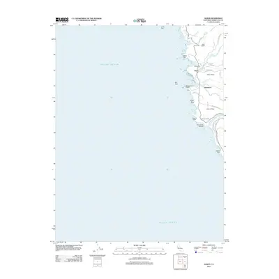
2012 Map of Albion
USGS Topo · Published 2012About this map
Albion sits perched above the Pacific Ocean coastline, a historical maritime and timber hub where the Albion River meets the sea. This 2012 survey illustrates the coastal geography of Mendocino County, showing how the landscape is defined by its deep gulches and prominent ridges that extend toward the shore. To the south, the settlement of Whitesboro and the nearby Whitesboro Cove indicate a shoreline shaped by years of coastal activity. The map reveals a complex interface between land and water, noted by features like Arch of the Navarro and the rocky shoals of Colby Reef. Inland, the terrain rises sharply into Albion Ridge and Navarro Ridge, with local life largely concentrated along the river valleys and coastal roads. Notable landmarks such as Albion Flat and Navarro Head provide specific reference points for understanding the historical development of this timber-rich region.
Find a feature on this map
30 named features on this map. Tap any name to fly to it.
Don’t see what you’re looking for? This feature index may not catch every label — zoom into the map to look around manually.
Map Details
Editions of this 2012 Albion Map
This is the sole edition of this map. No revisions or reprints were ever made.
Other maps of this area
1920 · Glenblair
USGS Topo · 1:62,500
1920 · Fort Bragg
USGS Topo · 1:62,500
1943 · Glenblair
USGS Topo · 1:62,500
1943 · Fort Bragg
USGS Topo · 1:62,500
1943 · Albion
USGS Topo · 1:62,500
1943 · Navarro
USGS Topo · 1:62,500
1944 · Saddle Point
USGS Topo · 1:62,500
1957 · Ukiah
USGS Topo · 1:250,000
1960 · Ukiah
USGS Topo · 1:250,000
1960 · Elk
USGS Topo · 1:24,000