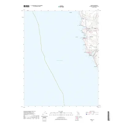
2018 Map of Albion
USGS Topo · Published 2018About this map
Albion River and the Navarro River carve deep outlets into the Mendocino coast on this 2018 survey. The settlement of Albion sits at the northern end of the map near Albion Cove, where the land rises sharply toward the residential corridors of Albion Ridge and Navarro Ridge. These ridges are defined by a network of local thoroughfares such as Albion Ridge Rd and Navarro Ridge Rd, reflecting the long-standing land use patterns that follow the natural topography of the coastal bench. To the south, the village of Whitesboro overlooks Whitesboro Cove, positioned between the river valleys.
Find a feature on this map
34 named features on this map. Tap any name to fly to it.
Don’t see what you’re looking for? This feature index may not catch every label — zoom into the map to look around manually.
Map Details
Editions of this 2018 Albion Map
This is the sole edition of this map. No revisions or reprints were ever made.
Other maps of this area

1920 · Glenblair
USGS Topo · 1:62,500

1920 · Fort Bragg
USGS Topo · 1:62,500

1943 · Glenblair
USGS Topo · 1:62,500

1943 · Fort Bragg
USGS Topo · 1:62,500

1943 · Albion
USGS Topo · 1:62,500

1943 · Navarro
USGS Topo · 1:62,500

1944 · Saddle Point
USGS Topo · 1:62,500

1957 · Ukiah
USGS Topo · 1:250,000

1960 · Ukiah
USGS Topo · 1:250,000
1960 · Elk
USGS Topo · 1:24,000