1968 Map of Alcester SE
USGS Topo · Published 1970About this map
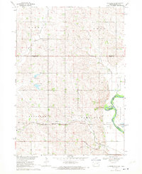
The Big Sioux River forms the natural boundary between South Dakota and Iowa in this late-1960s landscape, winding through Buncombe and marking the edge of Union Co. The agrarian character of the region is well-defined by the Chicago and North Western rail line, which cuts across the territory just north of the Alcester township line. This infrastructure supported a network of rural hubs, including several local schools such as East View Sch and Edwards Sch.
Find a feature on this map
26 named features on this map. Tap any name to fly to it.
Don’t see what you’re looking for? This feature index may not catch every label — zoom into the map to look around manually.
Map Details
Editions of this 1968 Alcester SE Map
This is the sole edition of this map. No revisions or reprints were ever made.
Other maps of this area

1897 · Canton
USGS Topo · 1:125,000

1898 · Elk Point
USGS Topo · 1:125,000

1900 · Canton
USGS Topo · 1:125,000

1901 · Elk Point
USGS Topo · 1:125,000

1907 · Elk Point
USGS Topo · 1:125,000

1955 · Sioux City
USGS Topo · 1:250,000

1955 · Sioux Falls
USGS Topo · 1:250,000

1958 · Sioux City
USGS Topo · 1:250,000

1958 · Sioux Falls
USGS Topo · 1:250,000

1959 · Sioux City
USGS Topo · 1:250,000
Featured Places
- Alcester, Alcester Township
- Virginia Township, SD
- Alcester Township, SD
- Norway Township, SD
- Eden Township, SD