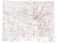
1958 Map of Sioux Falls
USGS Topo · Published 1958About this map
Sioux Falls serves as the regional anchor in this late 1950s survey of the tri-state borderlands where South Dakota, Minnesota, and Iowa meet. The landscape is defined by the heavy rail infrastructure of the era, with the Chicago Milwaukee St Paul and Pacific and Great Northern railroads threading through prairie settlements like Dell Rapids, Luverne, and Pipestone. The map details the transition from the James River valley in the west toward the glacial lake districts in the north, including Lake Herman and Lake Madison.
Find a feature on this map
155 named features on this map. Tap any name to fly to it.
Don’t see what you’re looking for? This feature index may not catch every label — zoom into the map to look around manually.
Map Details
Editions of this 1958 Sioux Falls Map
This is the sole edition of this map. No revisions or reprints were ever made.
Historical Maps of Sioux Falls Through Time
3 maps found