
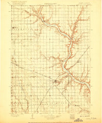
1898 Map of Olivet
USGS Topo · Published 1898About this map
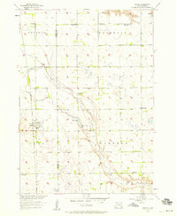
The James River meanders sharply through the heart of Hutchinson County, carving a valley that separates the township of Susquehanna from the developing railroad corridors to the east. This 1890s landscape reveals the importance of the Chicago Milwaukee and St Paul RR, which connects the growing hubs of Scotland and Menno. The map documents a period when the river was the primary natural landmark, yet the iron rail was rapidly dictating the placement of settlements like Parkston and Lesterville. Local genealogists will find value in the specific township boundaries and early rural post offices, including Mabel and Elmspring, which reflect the initial wave of homesteading across the prairie. The convergence of Wolf Creek and Lone Tree Creek with the main river channel highlights the drainage patterns that defined early farmstead viability in this corner of South Dakota.
Find a feature on this map
34 named features on this map. Tap any name to fly to it.
Don’t see what you’re looking for? This feature index may not catch every label — zoom into the map to look around manually.
Map Details
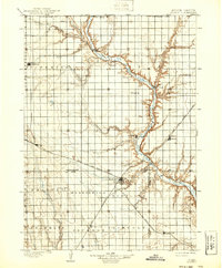
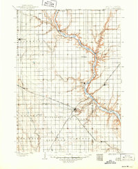
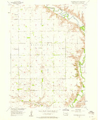
Editions of this 1898 Olivet Map
4 editions found
Other maps of this area

1898 · Parker
USGS Topo · 1:125,000

1899 · Mitchell
USGS Topo · 1:125,000

1899 · Alexandria
USGS Topo · 1:125,000

1955 · Sioux City
USGS Topo · 1:250,000

1955 · Sioux Falls
USGS Topo · 1:250,000

1955 · Mitchell
USGS Topo · 1:250,000

1955 · O'Neill
USGS Topo · 1:250,000
1957 · Tschetter Colony
USGS Topo · 1:24,000
1957 · Ethan
USGS Topo · 1:24,000
1957 · Midway
USGS Topo · 1:24,000
Featured Places
- Parkston, Liberty Township
- Scotland, Scotland Township
- Menno, Sweet Township
- Tripp, Fair Township
- Wolf Creek Hutterite Colony, Wolf Creek Township