
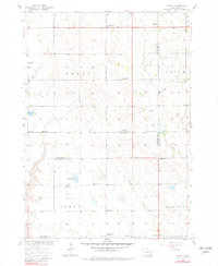
1957 Map of Midway
USGS Topo · Published 1958About this map
The agrarian landscape of southeastern South Dakota is documented here just as the Department of the Interior was developing the Missouri River Basin. The quadrangle spans portions of Molan, Salem, Jamesville, and Mayfield townships, revealing a dense network of one-room schoolhouses and country churches that anchored these prairie communities in the late 1950s. Named institutions such as Independence Sch, Molan Sch, and Morningstar Sch are spaced across the section lines, while religious life is centered at Salem Ch., Zion Ch, and Saron Ch. The terrain is characterized by prairie potholes and small drainages like Clay Creek and Mud Creek, with larger bodies of water including Ulmer Lake and Guthmiller Lake providing distinct landmarks. Near the southern border, the small settlement of Midway sits at a crossroads, serving as a focal point for the surrounding farmsteads.
Find a feature on this map
30 named features on this map. Tap any name to fly to it.
Don’t see what you’re looking for? This feature index may not catch every label — zoom into the map to look around manually.
Map Details
Editions of this 1957 Midway Map
2 editions found
Other maps of this area

1898 · Olivet
USGS Topo · 1:125,000

1898 · Parker
USGS Topo · 1:125,000

1955 · Sioux Falls
USGS Topo · 1:250,000

1957 · Mayfield
USGS Topo · 1:24,000

1957 · Menno
USGS Topo · 1:24,000

1957 · Wolf Creek
USGS Topo · 1:24,000

1957 · Jamesville
USGS Topo · 1:24,000

1958 · Sioux Falls
USGS Topo · 1:250,000

1970 · Turkey Ridge
USGS Topo · 1:24,000

1970 · Freeman SE
USGS Topo · 1:24,000