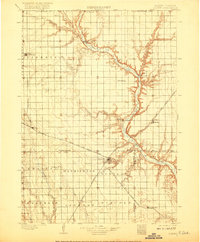
1898 Map of Olivet
USGS Topo · Published 1917About this map
The James River carves a deep, winding valley through the plains of southeastern South Dakota, serving as the central geographic feature for these late-nineteenth-century settlements. Olivet sits prominently near the river's bend, established as the county seat of Hutchinson Co. before the full expansion of the regional rail network. The landscape is a transition from open prairie to the deeply etched drainage basins of Wolf Creek and Twelvemile Creek.
Find a feature on this map
38 named features on this map. Tap any name to fly to it.
Don’t see what you’re looking for? This feature index may not catch every label — zoom into the map to look around manually.
Map Details
Editions of this 1898 Olivet Map
4 editions found
Other maps of this area

1898 · Olivet
USGS Topo · 1:125,000

1898 · Parker
USGS Topo · 1:125,000

1899 · Mitchell
USGS Topo · 1:125,000

1899 · Alexandria
USGS Topo · 1:125,000

1955 · Sioux City
USGS Topo · 1:250,000

1955 · Sioux Falls
USGS Topo · 1:250,000

1955 · Mitchell
USGS Topo · 1:250,000

1955 · O'Neill
USGS Topo · 1:250,000

1957 · Tschetter Colony
USGS Topo · 1:24,000

1957 · Ethan
USGS Topo · 1:24,000