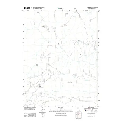
2012 Map of Alder Springs
USGS Topo · Published 2012About this map
Alder Springs Forest Service Facility anchors the lower-left portion of this Mendocino National Forest landscape, marking a center of operations within the Glenn County wilderness. The terrain is defined by dramatic elevation changes between Sanhedrin Ridge to the south and Hardin Hole Ridge to the north, with numerous springs and canyons carving the mountain face. Remote outposts and junctions such as Camp Ellendale, Alder Junction, and Fiddlers Green are linked by a network of forest routes, including Alder Springs Rd and Sanhedrin Rd. Water sources are vital to this environment, evidenced by the high concentration of named springs like Bathtub Spring, Hummingbird Spring, and Manzanita Spring. The placement of the Long Point Lookout suggests the critical importance of fire observation over the surrounding drainages of Grindstone Creek and Rattlesnake Creek.
Find a feature on this map
51 named features on this map. Tap any name to fly to it.
Don’t see what you’re looking for? This feature index may not catch every label — zoom into the map to look around manually.
Map Details
Editions of this 2012 Alder Springs Map
This is the sole edition of this map. No revisions or reprints were ever made.
Other maps of this area

1919 · Elk Creek
USGS Topo · 1:62,500

1948 · Elk Creek
USGS Topo · 1:62,500

1952 · Paskenta
USGS Topo · 1:62,500

1952 · Hull Mountain
USGS Topo · 1:62,500

1952 · Anthony Peak
USGS Topo · 1:62,500

1957 · Elk Creek
USGS Topo · 1:62,500

1957 · Ukiah
USGS Topo · 1:250,000

1960 · Ukiah
USGS Topo · 1:250,000
1967 · Plaskett meadows
USGS Topo · 1:24,000
1967 · Log Spring
USGS Topo · 1:24,000