
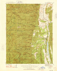
1948 Map of Elk Creek
USGS Topo · Published 1948About this map
Elk Creek serves as a focal point for this 1948 survey, where the western foothills of the Sacramento Valley meet the steep eastern slopes of the Mendocino National Forest. The landscape is defined by the sharp transition from the riparian environment of Stony Creek and the Stony Gorge Reservoir to the complex ridgelines of the Coast Range. Small settlements and specialized agriculture, such as Valley View Orchard and Dixon Orchard, are scattered through the canyons. Notable local features include the Grindstone Rancheria Indian Res near the northern boundary and several established family holdings like the Gillaspy Ranch and Rowcroft Ranch. Significant infrastructure like the Long Point Lookout and the Cache Tool Way underscores the region's historical importance for forest management and fire prevention during the post-war era.
Find a feature on this map
68 named features on this map. Tap any name to fly to it.
Don’t see what you’re looking for? This feature index may not catch every label — zoom into the map to look around manually.
Map Details
Editions of this 1948 Elk Creek Map
2 editions found
Other maps of this area

1919 · Fruto
USGS Topo · 1:62,500

1919 · Elk Creek
USGS Topo · 1:62,500

1922 · Hullville
USGS Topo · 1:62,500

1943 · Lodoga
USGS Topo · 1:62,500

1944 · Fruto
USGS Topo · 1:62,500

1944 · Flournoy
USGS Topo · 1:62,500

1951 · Lake Pillsbury
USGS Topo · 1:62,500

1951 · Stonyford
USGS Topo · 1:62,500

1952 · Paskenta
USGS Topo · 1:62,500

1952 · Hull Mountain
USGS Topo · 1:62,500