Old Maps of Lake County, California
Explore 309 old maps of Lake County, spanning from 1919 to today. These high-resolution historic maps reveal how streets, neighborhoods, landmarks, and natural features evolved over time — perfect for genealogy, metal detecting, research, and local history exploration.
What you can do with these maps:
- See how Lake County changed over time: Compare historical maps to modern-day views to trace roads, homesites, rail lines & more.
- View detailed metadata: Each map includes creators, publishers, year, scale, and archive source.
- Overlay maps with satellite & LiDAR: Visualize the past alongside modern tools to explore terrain & human change.
- Trusted historical sources: Maps sourced from the USGS, Library of Congress, and other archives.
- Access maps your way: View online, download high-res files, or order prints for personal or research use.
Start exploring old maps of Lake County to uncover forgotten places, hidden landmarks, and the deep history beneath your feet.
Lake County, CA maps
(309)- 1919 Map of Elk Creek, 1939 Print
 1919 Elk Creek1939 Print · USGSGlenn County ranching and forest lands are shown here just after the Great War, when pack trails still connected remote mountain outposts. Trace the early routes to Oriental, Ivory Mill, and the settlement at Elk Creek.
 - 1920 Map of Venado
 1920 Venado1920 Print · USGSColusa County mineral springs and mountain passes are captured here during the years following the Great War. Researchers can trace the path of the Colusa & Lake R.R. (Abandoned) and locate historic mining sites like the Abbott Mercury Mine and Wilbur Springs.
 - 1920 Map of Ukiah
 1920 Ukiah1920 Print · USGSMendocino County life centers on the Russian River valley during the years following the first World War. Family historians can locate specific homesteads like Roderis Ranch and trace rail operations at El Roble Siding or Clemhurst Spur.
 - 1921 Map of Kelseyville
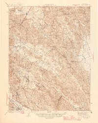
 1921 Kelseyville1921 Print · USGSNorthern California's thermal springs and mining districts are in full view in this early twentieth-century survey of Lake and Sonoma counties. Researchers can trace historic ranch boundaries like Moulton Ranch or locate vanished operations at the Cloverdale Quicksilver Mine and the Geyser Hotel.
 - 1922 Map of Hullville
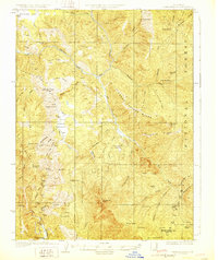
 1922 Hullville1922 Print · USGSThe pre-reservoir wilderness of Lake County is captured in this 1916 survey, shortly before the valley was flooded. Genealogists and historians can trace early homesteads and camps like Hullville, Boardman Camp, and Masons along the South Fork Eel River.
 - 1924 Map of Bartlett Springs
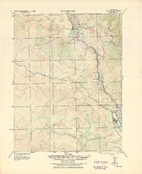
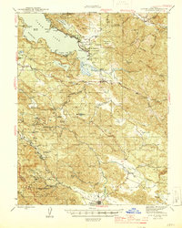
 1924 Bartlett Springs1924 Print · USGSNorthern Lake County mineral springs and canyons are captured here in the years following the Great War. Genealogists and historians can trace the early resort era at Bartlett Springs, Allen Springs, and the waters of Clear Lake.
 - 1927 Map of Calistoga
 1927 Calistoga1927 Print · USGSUpper Napa Valley and the surrounding peaks come alive in this 1920s tactical survey. Genealogists and researchers can trace the early mercury industry at the Oat Hill Mine, locate family roots near Langstry Ranch, or follow the old Southern Pacific line through Larkmead and Bale.2 unique versions available
 - 1929 Map of Eden Valley
 1929 Eden Valley1929 Print · USGSMendocino County’s interior wilderness is captured in the late 1920s, showing a landscape defined by the Eel River and remote mountain camps. Researchers can locate early family-named outposts like Crocker Place and trace the historic Mendenhall Trail through the high country.2 unique versions available
 - 1938 Map of Lakeport
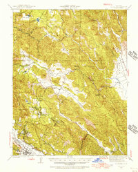
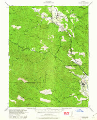
 1938 Lakeport1938 Print · USGSLake County in the late thirties is captured here at a peak of lakeside development and rural industry. Genealogists and historians can trace family-named sites like Jones Ranch and Mission Rancheria, or locate old schoolhouses like Westlake Sch and Glen Eden Sch.3 unique versions available
 - 1938 Map of Hopland
 1938 Hopland1938 Print · USGSNorthern California’s Russian River valley is captured here in the 1920s, showing the early rail-and-road network between Hopland and Cloverdale. Trace old rail stops like Thorn Siding and historic locations such as Duncan Springs and Preston.
 - 1942 Map of Bartlett Springs
 1942 Bartlett Springs1942 Print · USGSLake County and the rugged North Coast Ranges are captured here in the early 1940s, balancing resort springs with hardscrabble ranching. Genealogists can locate family landmarks like Garner Ranch, the East Lake Sch, and the isolated Bartlett Springs resort.
 - 1942 Map of St. Helena, 1966 Print
 1942 St. Helena1966 Print · USGSNapa County during the early 1940s is defined by its rural school districts and the emerging institutional centers of the Howell Mountain area. Genealogists can trace family footprints through the Silverado Trail, the Aetna Mine, and small schools like Hardin Sch.
 - 1943 Map of Morgan Valley
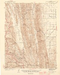
 1943 Morgan Valley1943 Print · USGSNorthern California ranching and mining country are captured in the early 1940s at the junction of Lake, Napa, and Yolo counties. Researchers can locate the Morgan Valley Sch and several mines like the Harrison Mine and Red Elephant Mine.
 - 1943 Map of Pomo, 1954 Print
 1943 Pomo1954 Print · USGSMendocino County's ranching and irrigation landscapes are captured here during the 1940s, showcasing the development of Potter Valley. Genealogists and historians can locate family lands like Mewhinney Ranch alongside the Pomo Indian Reservation and the Emandale Resort.
 - 1943 Map of Calistoga, 1955 Print
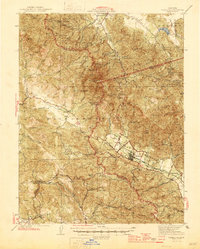
 1943 Calistoga1955 Print · USGSUpper Napa Valley and the rugged Lake County border are captured here during the 1940s, a period defined by mercury mining and early tourism. Researchers can trace family-named landmarks and industrial sites like the Oat Hill Mine, Mark West Springs, and the Petrified Forest.
 - 1943 Map of Kelseyville, 1959 Print
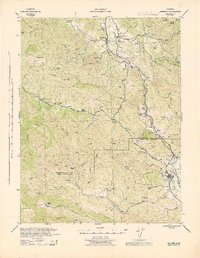
 1943 Kelseyville1959 Print · USGSIn the early 1940s, this region of Lake and Sonoma counties was a mosaic of active ranching and mountain retreats. Researchers can trace family-named lands like Fifield Ranch, locate the Socrates Mine, or find the historic Geyser Resort and Mountain School.
 - 1943 Map of Hopland, 1960 Print
 1943 Hopland1960 Print · USGSMendocino County ranching and the Russian River valley are captured here in the early 1940s as the rail and road networks matured. Researchers can trace family-named lands like McDowell Ranch, the Nacomis Indian Rancheria, and the operations at Thorn Siding.
 - 1944 Map of Bartlett Springs
 1944 Bartlett Springs1944 Print · USGSLake County at the height of the war years reveals a landscape of isolated springs and family-run ranches nestled along the high ridges. Researchers can trace historic homesteads like the Garner Ranch, the site of Bartlett Springs, and the East Lake Sch near the Clear Lake shoreline.2 unique versions available
 - 1944 Map of Ukiah
 1944 Ukiah1944 Print · USGSThe Russian River valley in the mid-1940s is a landscape of established ranching, tribal lands, and the vital Northwestern Pacific rail line. Researchers can locate family landmarks like Bartlett Ranch, the McNear School, and several tribal areas including Ukiah Rancheria.
 - 1944 Map of Wilbur Springs
 1944 Wilbur Springs1944 Print · USGSNorthern California mining country comes to life in this mid-forties survey of the Coast Ranges. Researchers can trace the quicksilver industry through sites like Abbott Mine and locate rural family history at Leesville or the Huffmaster Ranch.3 unique versions available
 - 1944 Map of Morgan Valley
 1944 Morgan Valley1944 Print · USGSUpper California ranching and mercury mining country are shown here in the mid-1940s near the corner of Lake, Colusa, and Napa counties. Researchers can trace historic operations like Reid Mine, the old Morgan Valley Sch, and local hubs like Knoxville.2 unique versions available
 - 1944 Map of Hopland
 1944 Hopland1944 Print · USGSThe Russian River valley in the 1940s was a landscape of remote ranches and rail sidings on the Mendocino-Sonoma border. Researchers can trace the Northwestern Pacific Railroad through Pieta, find the old McDonald School, or locate the Nacomis Indian Rancheria.
 - 1945 Map of Calistoga
 1945 Calistoga1945 Print · USGSCalistoga and the surrounding tri-county ridges are documented here during the mid-forties, capturing a landscape defined by mercury and silver mining. Researchers can trace the Southern Pacific RR and locate rural landmarks like the Silverado Mine or Mark West Springs.2 unique versions available
 - 1945 Map of St. Helena
 1945 St. Helena1945 Print · USGSNapa County at the end of the war shows a landscape of growing valley towns, mountain colleges, and rural mining outposts. Researchers can trace the path of the Southern Pacific RR or locate family roots near Central Sch and the Aetna Mine.2 unique versions available
 - 1945 Map of Lower Lake
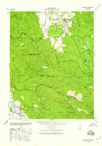
 1945 Lower Lake1945 Print · USGSLake County's famous resort and mercury-mining districts are shown in high detail during the mid-1940s. Researchers can locate vanished structures at Hould Gibson Camp, trace the namesake springs at Anderson Springs, and find rural institutions like Cobb Valley Sch.2 unique versions available
Showing maps 1-25 of 309
Top cities of Lake County
- Clearlake historical maps
- Lakeport historical maps
- Clearlake Riviera historical maps
- Kelseyville historical maps
- Lucerne historical maps
- Nice historical maps
See more
Frequently asked questions
- What are the different types of historical maps available for Lake County?
- What is the oldest map of Lake County?
- Where can I purchase historical maps of Lake County for my home or office?
- Where can I download high-res historical maps of Lake County?
- Are there historical topographic maps available for Lake County?
- Is there historical aerial imagery available for Lake County?
- Where are historical maps of Lake County sourced from?