
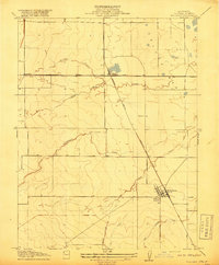
1920 Map of Venado
USGS Topo · Published 1920About this map
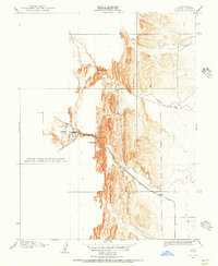
Bear Valley and the surrounding Coast Range foothills are depicted here following a period of significant mineral exploration and early infrastructure development. The map reveals a remote landscape transitioning away from its nineteenth-century peaks, most notably evidenced by the Colusa & Lake R.R. (Abandoned) which once connected these hills to the valley floor. Near the southern edge, the concentration of mining activity around Wilbur Springs and Jones Springs is prominent, featuring the Monzanela Gold Mine, the Wide Awake Mercury Mine, and the Abbott Mercury Mine.
Find a feature on this map
15 named features on this map. Tap any name to fly to it.
Don’t see what you’re looking for? This feature index may not catch every label — zoom into the map to look around manually.
Map Details
Editions of this 1920 Venado Map
This is the sole edition of this map. No revisions or reprints were ever made.
Other maps of this area
1904 · Sites
USGS Topo · 1:24,000

1905 · Fairview
USGS Topo · 1:24,000
1906 · Maxwell
USGS Topo · 1:62,500
1907 · Colusa
USGS Topo · 1:62,500
1917 · Sites
USGS Topo · 1:31,680

1917 · Delevan
USGS Topo · 1:31,680
1918 · Williams
USGS Topo · 1:31,680
1918 · Spring Valley
USGS Topo · 1:31,680

1924 · Bartlett Springs
USGS Topo · 1:62,500
1942 · Colusa
USGS Topo · 1:62,500