
1907 Map of Colusa
USGS Topo · Published 1907About this map
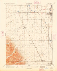
Agricultural development and early rail corridors define this portion of the Sacramento Valley just after the turn of the century. The Colusa and Lake R R connects the regional hub of Colusa westward to Colusa Junction, while the main line of the Southern Pacific R R (San Francisco and Tehama Line) runs north-south through Williams, Macy, and Arbuckle. This rail network supported a landscape increasingly managed for irrigation, evidenced by the extensive Cheney Slough and Irrigation Company Canal and the Lurline Canal. To the west, the flat valley floor transitions into the foothills of Spring Valley, where the headwaters of Cortina Creek and Sand Creek emerge. The map also captures infrastructure critical to flood management and river navigation, including the Davis Levee and the Old Davis Levee along the eastern sloughs and bends of the Sacramento River system.
Find a feature on this map
31 named features on this map. Tap any name to fly to it.
Don’t see what you’re looking for? This feature index may not catch every label — zoom into the map to look around manually.
Map Details
Editions of this 1907 Colusa Map
3 editions found

Other maps of this area

1888 · Marysville
USGS Topo · 1:125,000

1891 · Marysville
USGS Topo · 1:125,000

1894 · Marysville
USGS Topo · 1:125,000

1895 · Marysville
USGS Topo · 1:125,000

1904 · Sites
USGS Topo · 1:24,000

1905 · Harrington
USGS Topo · 1:24,000

1905 · Fairview
USGS Topo · 1:24,000

1906 · Maxwell
USGS Topo · 1:62,500

1907 · Dunnigan
USGS Topo · 1:62,500

1911 · Sanborn Slough
USGS Topo · 1:31,680