1950s Maps of Lake County, California
Explore 36 historic maps of Lake County from the 1950s. These maps offer a rare glimpse into what life looked like during the 1950s — showing old roads, neighborhoods, homes, and landmarks that have changed or disappeared over time.
Whether you're researching your family's past, planning a metal detecting trip, or studying how Lake County's landscape evolved across the 1950s, these high-resolution maps are a powerful tool for exploring the history of this region.
- Focus on a specific era: All maps on this page are from the 1950s, giving you a focused view of this time period.
- See what’s changed: Compare century-old streets, trails, and buildings to today's modern landscape using overlays and satellite layers.
- Research with precision: Use these maps for genealogy, historical research, land use analysis, or educational projects.
- View, download, or print: Maps are fully viewable online in high resolution, and can be downloaded or printed for your own records.
Start exploring Lake County's history through authentic maps from the 1950s. This is your window into the past.
Lake County, CA maps
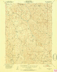
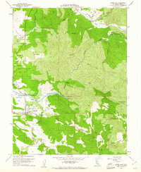
(36)- 1951 Map of Lake Pillsbury, 1953 Print
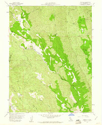
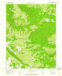
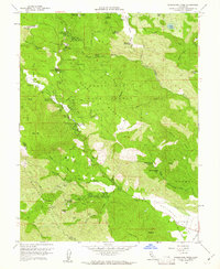
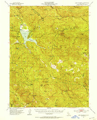 1951 Lake Pillsbury1953 Print · USGSLake County and the Mendocino National Forest are captured in the early fifties as a landscape of remote ranches and timber mills. Genealogists and historians can locate legacy sites like Fuller Ranch, Prather Mill, and the Snow Mtn House.5 unique versions available
 - 1951 Map of Lakeport, 1953 Print
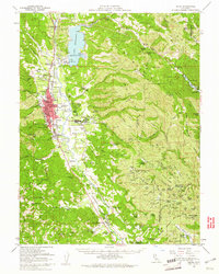
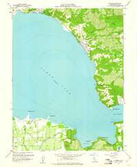
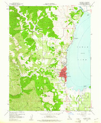
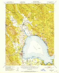 1951 Lakeport1953 Print · USGSNorthern California lake life and tribal history meet in the early fifties around the shores of Clear Lake. Trace the locations of the Upper Lake Rancheria, the Bloody Island Massacre Historic Marker, and the early layout of Lakeport.2 unique versions available
 - 1951 Map of Stonyford, 1953 Print
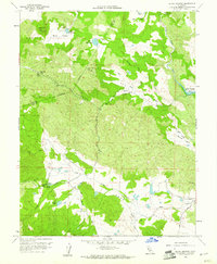
 1951 Stonyford1953 Print · USGSColusa and Glenn counties were still characterized by remote forest outposts and mineral springs in the early fifties. Local historians can trace family sites like Brittan Ranch or search for the Ruby King Mine and the historical Stonyford Rancheria (Site).3 unique versions available
 - 1952 Map of Hull Mountain, 1954 Print
 1952 Hull Mountain1954 Print · USGSThe high ridges of Mendocino National Forest are captured here in the early 1950s, showing a landscape shaped by forest service outposts and remote mountain camps. Researchers can find old backcountry locations like Plaskett Guard Sta, Millsap Cabin, and the high meadows of Black Butte.3 unique versions available
 - 1952 Map of Eden Valley, 1954 Print
 1952 Eden Valley1954 Print · USGSMendocino County's high ridges and river forks are captured here in the early fifties, documenting a landscape of remote ranching outposts and deep forest wilderness. Researchers can trace historic sites like Eden Valley Ranch, Elk Creek Ranch, and the high summit of Mt Sanhedrin.4 unique versions available
 - 1957 Map of Elk Creek, 1959 Print
 1957 Elk Creek1959 Print · USGSThe eastern foothills of the Mendocino National Forest come alive in the late 1950s, centered on the community of Elk Creek. Genealogists and historians can trace ranching heritage at El Manzano Rancho or explore the early shoreline of Stony Gorge Reservoir.2 unique versions available
 - 1957 Map of Ukiah, 1966 Print
 1957 Ukiah1966 Print · USGSNorthern California's diverse terrain comes into focus in the mid-1950s, from the rugged timberlands of the Jackson State Forest to the productive Sacramento Valley. Genealogists and historians can trace the rail lines of the Northwestern Pacific or locate early valley settlements like Arbuckle and Paskenta.3 unique versions available
 - 1958 Map of Purdys Gardens, 1960 Print
 1958 Purdys Gardens1960 Print · USGSThe Mendocino and Lake County line comes alive in the late fifties, showing a landscape of remote mountain ranches and seasonal camps. Genealogists and historians can trace family-named sites like Ruddick Ranch, Dorst Ranch, and James Cabin along the Russian River and high ridges.3 unique versions available
 - 1958 Map of Cow Mountain, 1960 Print
 1958 Cow Mountain1960 Print · USGSThe Mendocino and Lake County line follows the high ridges of the Northern Coast Ranges during the late fifties. Genealogists and historians can locate remote homesteads like Hemlock Ranch and Lona Loa Farm or trace the drainage of Sulphur Creek and Blue Lakes.2 unique versions available
 - 1958 Map of Knoxville, 1961 Print
 1958 Knoxville1961 Print · USGSNapa County's rugged mining interior is captured in the late fifties, centered on the historic quicksilver district. Genealogists and historians can trace the footprint of the Manhattan Mine, the settlement of Knoxville, and natural landmarks like Zim Zim Falls.3 unique versions available
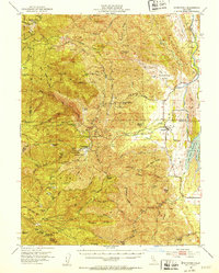
 - 1958 Map of Ukiah, 1961 Print
 1958 Ukiah1961 Print · USGSMendocino County's interior valleys thrive in the late fifties as the regional hub of Ukiah grows alongside the Russian River. Genealogists and historians can trace family landholdings like W L Crawford Ranch and visit landmarks such as Vichy Springs or the Mendocino State Hospital.2 unique versions available
 - 1958 Map of Middletown, 1961 Print
 1958 Middletown1961 Print · USGSMiddletown and the surrounding Lake County valleys are shown here in the late fifties, during a period of steady ranching and early water management. Researchers can locate the Cem near the town center or trace the course of Putah Creek past the Military Reservation and McCreary Lake.3 unique versions available
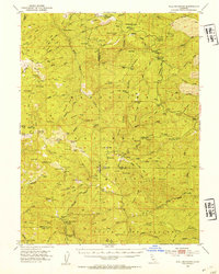
 - 1958 Map of Wilson Valley, 1961 Print
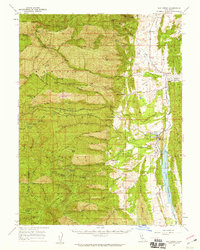
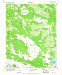
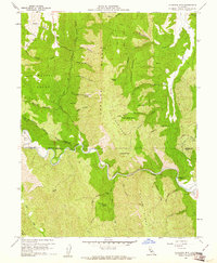
 1958 Wilson Valley1961 Print · USGSThe Lake County backcountry in the late fifties is defined by the winding course of Cache Creek and isolated upland basins. Researchers can trace historic access routes via jeep trails to remote landmarks like Dunfield Spring and Kennedy Flats.3 unique versions available
 - 1958 Map of Lower Lake, 1961 Print
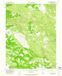
 1958 Lower Lake1961 Print · USGSLower Lake and the surrounding Lake County valleys are captured here in the late fifties, showcasing a landscape defined by the winding waters of Cache Creek. Researchers can trace the layout of the town near Union High Sch or locate rural landmarks like the Baker Mine and Pearce Airport.5 unique versions available
 - 1958 Map of Jericho Valley, 1961 Print
 1958 Jericho Valley1961 Print · USGSLake County ranching and mining country are detailed in the late fifties, showing the rugged borderlands with Napa County. Genealogists and historians can trace family-named sites like Ink Ranch and the Red Elephant Mine alongside Amel Lake.4 unique versions available
 - 1958 Map of Glascock Mtn, 1961 Print
 1958 Glascock Mtn1961 Print · USGSThe Inner Coast Ranges come into focus in the late fifties at the intersection of Colusa, Lake, and Yolo counties. Trace the winding path of Cache Creek past Camp Haswell (BSA) or locate landmarks like Glascock Mtn and Buck Island.4 unique versions available
 - 1958 Map of Clearlake Oaks, 1961 Print
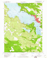
 1958 Clearlake Oaks1961 Print · USGSClear Lake’s northeast shore comes into focus during the late 1950s, showing the early development of Clearlake Oaks and Glenhaven. Researchers can trace the legacy of local industry and education at the Sulphur Bank Mine, SULPHUR BANK RANCHERIA, and the East Lake School.7 unique versions available
 - 1958 Map of Bartlett Mtn, 1961 Print
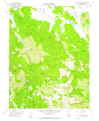
 1958 Bartlett Mtn1961 Print · USGSLake County high country comes into focus in the late fifties as the Mendocino National Forest backcountry remains a land of primitive jeep trails and isolated mountain camps. Researchers can locate vanished sites like the Wild Bill Place and Crabtree Lodge or trace the early footprint of Nice.5 unique versions available
 - 1958 Map of Detert Reservoir, 1961 Print
 1958 Detert Reservoir1961 Print · USGSThe Mayacamas Mountains in the late fifties remained a rugged hub of mercury and silver mining. Genealogists and industrial historians can trace the foundations of the Oat Hill Mine, Corona Mine, and Silverado Mine along the winding Old Grade.5 unique versions available
 - 1958 Map of Lucerne, 1961 Print
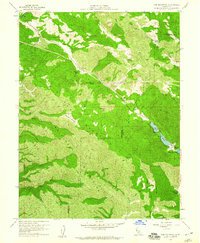
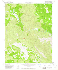
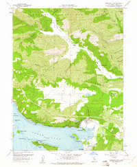
 1958 Lucerne1961 Print · USGSClear Lake's eastern shoreline is captured in the late fifties, showing the region's balance between forest wilderness and emerging lakeside communities. Genealogists and researchers can trace local developments from Lucerne and Nice down to the agricultural plots around Finley and the geologically unique Little Borax Lake.4 unique versions available
 - 1958 Map of Upper Lake, 1961 Print
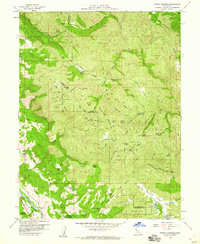
 1958 Upper Lake1961 Print · USGSUpper Lake and the Bachelor Valley are shown here in the late fifties as agriculture and tribal lands met the forest edge. Local historians can find the Bloody Island Massacre Historical Marker, the Witter Springs P.O., and several rancheria tracts.3 unique versions available
 - 1958 Map of Whispering Pines, 1961 Print
 1958 Whispering Pines1961 Print · USGSLake County at the end of the 1950s was a hub for mineral spring resorts and mountain industry. Genealogists and historians can trace the foundations of Hobergs, Anderson Springs, and Harbin Springs, or locate old operations like the Big Chief Mine.4 unique versions available
 - 1958 Map of Lakeport, 1961 Print
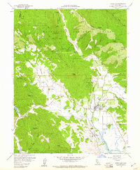
 1958 Lakeport1961 Print · USGSThe western shores of Clear Lake come alive in the late 1950s, detailing a period of agricultural and civic growth. Genealogists and historians can trace family-named sites and landmarks like Hartley Cemetery, Scotts Valley Rancheria, and Westlake Sch.5 unique versions available
 - 1958 Map of Clearlake Highlands, 1961 Print
 1958 Clearlake Highlands1961 Print · USGSClear Lake's eastern shoreline and the surrounding volcanic highlands are captured here during the late 1950s. Genealogists and local historians can trace the development of Clearlake Highlands and find legacy landmarks like the Burns Valley Sch and Salminas Resort.5 unique versions available
 - 1958 Map of Aetna Springs, 1961 Print
 1958 Aetna Springs1961 Print · USGSNapa County's rugged backcountry comes into focus in the late fifties, showing the historic thermal resort at Aetna Springs and the early stages of Lake Berryessa. Researchers can trace old mining operations like the Aetna Mine and remote family landmarks along Stone Corral Trail.6 unique versions available
Showing maps 1-25 of 36
Top cities of Lake County
- Clearlake historical maps
- Lakeport historical maps
- Clearlake Riviera historical maps
- Kelseyville historical maps
- Lucerne historical maps
- Nice historical maps
See more
Frequently asked questions
- What are the different types of historical maps available for Lake County?
- What is the oldest map of Lake County?
- Where can I purchase historical maps of Lake County for my home or office?
- Where can I download high-res historical maps of Lake County?
- Are there historical topographic maps available for Lake County?
- Is there historical aerial imagery available for Lake County?
- Where are historical maps of Lake County sourced from?