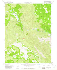
1958 Map of Wilson Valley
USGS Topo · Published 1961About this map
Cache Creek winds through this northern California landscape, carving a deep path through the canyon lands of the Coast Ranges at the end of the 1950s. The map illustrates a transitional terrain where the borders of Lake, Colusa, and Yolo counties converge. Remote valleys like Wilson Valley and the broader Morgan Valley provide a stark contrast to the surrounding heights of Little Blue Ridge and Grizzly Peak. This survey is particularly useful for identifying the specific locations of water sources in an arid region, such as Dunfield Spring and Bear Spring. Landmarks like The Peninsula and Kennedy Flats reveal the complex topography of the watershed, while numerous jeep trails and canyon names like Stemple Canyon and Thompson Canyon suggest a history of grazing and transit through these high basins.
Find a feature on this map
36 named features on this map. Tap any name to fly to it.
Don’t see what you’re looking for? This feature index may not catch every label — zoom into the map to look around manually.
Map Details
Editions of this 1958 Wilson Valley Map
3 editions found
Other maps of this area

1920 · Venado
USGS Topo · 1:62,500

1924 · Bartlett Springs
USGS Topo · 1:62,500

1942 · Bartlett Springs
USGS Topo · 1:62,500

1943 · Morgan Valley
USGS Topo · 1:62,500

1944 · Bartlett Springs
USGS Topo · 1:62,500

1944 · Wilbur Springs
USGS Topo · 1:62,500

1944 · Morgan Valley
USGS Topo · 1:62,500

1945 · Lower Lake
USGS Topo · 1:62,500

1947 · Santa Rosa
USGS Topo · 1:250,000

1949 · Santa Rosa
USGS Topo · 1:250,000