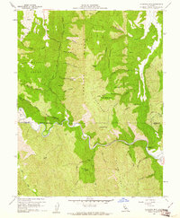
1958 Map of Glascock Mtn
USGS Topo · Published 1961About this map
Cache Creek dominates the southern half of this landscape, winding through a complex junction of the Colusa, Lake, and Yolo county lines. This 1950s terrain study reveals a topography defined by prominent geological spine-like formations, including the Cortina Ridge, Blue Ridge, and the Swanson Range. Near the creek's bend sits Camp Haswell (BSA), a clear marker of mid-century recreation in this mountainous region. The map captures the remote nature of the Inner Coast Ranges, where isolated points like Glascock Mtn and Langs Peak overlook a network of seasonal drainages and springs, such as Little Sulphur Spring and Holsten Chimney Canyon Spring. Numerous jeep trails provide the only access through The Redlands and along Cache Creek Ridge, indicating the area's use for ranching or resource management at the time of the survey.
Find a feature on this map
50 named features on this map. Tap any name to fly to it.
Don’t see what you’re looking for? This feature index may not catch every label — zoom into the map to look around manually.
Map Details
Editions of this 1958 Glascock Mtn Map
4 editions found
Other maps of this area

1907 · Colusa
USGS Topo · 1:62,500

1918 · Spring Valley
USGS Topo · 1:31,680

1920 · Venado
USGS Topo · 1:62,500

1942 · Colusa
USGS Topo · 1:62,500

1943 · Morgan Valley
USGS Topo · 1:62,500

1944 · Wilbur Springs
USGS Topo · 1:62,500

1944 · Morgan Valley
USGS Topo · 1:62,500

1945 · Rumsey
USGS Topo · 1:62,500

1947 · Santa Rosa
USGS Topo · 1:250,000

1949 · Santa Rosa
USGS Topo · 1:250,000