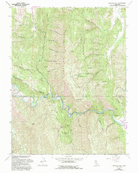
1958 Map of Glascock Mtn
USGS Topo · Published 1993About this map
Cache Creek winds through the heart of this landscape, cutting deep canyons between the prominent elevations of Cortina Ridge and Blue Ridge. The terrain is defined by its dramatic relief, where Glascock Mtn and Langs Peak overlook a complex network of seasonal drainages including Fiske Creek and Bear Creek. This 1958 survey, updated with 1980s aerial data, reveals a wilderness largely defined by its natural topography rather than dense settlement.
Find a feature on this map
59 named features on this map. Tap any name to fly to it.
Don’t see what you’re looking for? This feature index may not catch every label — zoom into the map to look around manually.
Map Details
Editions of this 1958 Glascock Mtn Map
4 editions found
Other maps of this area

1907 · Colusa
USGS Topo · 1:62,500

1918 · Spring Valley
USGS Topo · 1:31,680

1920 · Venado
USGS Topo · 1:62,500

1942 · Colusa
USGS Topo · 1:62,500

1943 · Morgan Valley
USGS Topo · 1:62,500

1944 · Wilbur Springs
USGS Topo · 1:62,500

1944 · Morgan Valley
USGS Topo · 1:62,500

1945 · Rumsey
USGS Topo · 1:62,500

1947 · Santa Rosa
USGS Topo · 1:250,000

1949 · Santa Rosa
USGS Topo · 1:250,000