1920s Maps of Lake County, California
Explore 7 historic maps of Lake County from the 1920s. These maps offer a rare glimpse into what life looked like during the 1920s — showing old roads, neighborhoods, homes, and landmarks that have changed or disappeared over time.
Whether you're researching your family's past, planning a metal detecting trip, or studying how Lake County's landscape evolved across the 1920s, these high-resolution maps are a powerful tool for exploring the history of this region.
- Focus on a specific era: All maps on this page are from the 1920s, giving you a focused view of this time period.
- See what’s changed: Compare century-old streets, trails, and buildings to today's modern landscape using overlays and satellite layers.
- Research with precision: Use these maps for genealogy, historical research, land use analysis, or educational projects.
- View, download, or print: Maps are fully viewable online in high resolution, and can be downloaded or printed for your own records.
Start exploring Lake County's history through authentic maps from the 1920s. This is your window into the past.
Lake County, CA maps
(7)- 1920 Map of Venado
 1920 Venado1920 Print · USGSColusa County mineral springs and mountain passes are captured here during the years following the Great War. Researchers can trace the path of the Colusa & Lake R.R. (Abandoned) and locate historic mining sites like the Abbott Mercury Mine and Wilbur Springs.
 - 1920 Map of Ukiah
 1920 Ukiah1920 Print · USGSMendocino County life centers on the Russian River valley during the years following the first World War. Family historians can locate specific homesteads like Roderis Ranch and trace rail operations at El Roble Siding or Clemhurst Spur.
 - 1921 Map of Kelseyville
 1921 Kelseyville1921 Print · USGSNorthern California's thermal springs and mining districts are in full view in this early twentieth-century survey of Lake and Sonoma counties. Researchers can trace historic ranch boundaries like Moulton Ranch or locate vanished operations at the Cloverdale Quicksilver Mine and the Geyser Hotel.
 - 1922 Map of Hullville
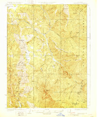
 1922 Hullville1922 Print · USGSThe pre-reservoir wilderness of Lake County is captured in this 1916 survey, shortly before the valley was flooded. Genealogists and historians can trace early homesteads and camps like Hullville, Boardman Camp, and Masons along the South Fork Eel River.
 - 1924 Map of Bartlett Springs
 1924 Bartlett Springs1924 Print · USGSNorthern Lake County mineral springs and canyons are captured here in the years following the Great War. Genealogists and historians can trace the early resort era at Bartlett Springs, Allen Springs, and the waters of Clear Lake.
 - 1927 Map of Calistoga
 1927 Calistoga1927 Print · USGSUpper Napa Valley and the surrounding peaks come alive in this 1920s tactical survey. Genealogists and researchers can trace the early mercury industry at the Oat Hill Mine, locate family roots near Langstry Ranch, or follow the old Southern Pacific line through Larkmead and Bale.2 unique versions available
 - 1929 Map of Eden Valley
 1929 Eden Valley1929 Print · USGSMendocino County’s interior wilderness is captured in the late 1920s, showing a landscape defined by the Eel River and remote mountain camps. Researchers can locate early family-named outposts like Crocker Place and trace the historic Mendenhall Trail through the high country.2 unique versions available
End of results
Showing maps 1-7 of 7
Top cities of Lake County
- Clearlake historical maps
- Lakeport historical maps
- Clearlake Riviera historical maps
- Kelseyville historical maps
- Lucerne historical maps
- Nice historical maps
See more
Frequently asked questions
- What are the different types of historical maps available for Lake County?
- What is the oldest map of Lake County?
- Where can I purchase historical maps of Lake County for my home or office?
- Where can I download high-res historical maps of Lake County?
- Are there historical topographic maps available for Lake County?
- Is there historical aerial imagery available for Lake County?
- Where are historical maps of Lake County sourced from?