
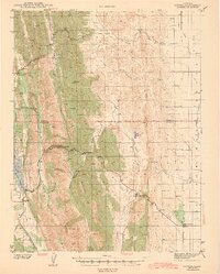
1943 Map of Lodoga
USGS Topo · Published 1943About this map
Lodoga and the foothills of the Coast Range appear here during the early 1940s, a period when local geography was being reshaped by large-scale water management. The eastern edge of the map features the Central Valley Project and a prominent Irrigation Canal, signaling the agricultural transformation of the Sacramento Valley floor. In contrast, the western uplands remain defined by a network of seasonal drainages and steep topography, including the rugged Logan Ridge and Black Mtn.
Find a feature on this map
39 named features on this map. Tap any name to fly to it.
Don’t see what you’re looking for? This feature index may not catch every label — zoom into the map to look around manually.
Map Details
Editions of this 1943 Lodoga Map
2 editions found
Other maps of this area

1904 · Logan Creek
USGS Topo · 1:24,000

1904 · Sites
USGS Topo · 1:24,000

1905 · Fairview
USGS Topo · 1:24,000

1906 · Maxwell
USGS Topo · 1:62,500

1906 · Willows
USGS Topo · 1:62,500

1907 · Colusa
USGS Topo · 1:62,500

1917 · Kurand
USGS Topo · 1:31,680

1917 · Lyman
USGS Topo · 1:31,680

1917 · Logandale
USGS Topo · 1:31,680

1917 · Sites
USGS Topo · 1:31,680