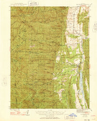
1948 Map of Elk Creek
USGS Topo · Published 1948About this map
Mendocino National Forest dominates the western landscape of this 1948 survey, where the steep terrain of the California Coast Ranges is defined by a dense network of ridges and canyons. To the east, the topography transitions into the foothills where Stony Creek flows toward the newly formed Stony Gorge Reservoir. The map documents a sparsely populated region of significant ranching and agricultural activity, evidenced by operations like Valley View Orchard and Gillaspy Ranch. Local history is anchored by the Grindstone Rancheria Indian Res and the small settlement of Chrome. In the higher elevations, seasonal or administrative outposts such as Alder Springs, Smiley Camp, and Butler Camp appear along the forest boundaries. The survey also traces the Lake Co Glenn Co border as it traverses through features like Kern Point and Kern Ridge.
Find a feature on this map
57 named features on this map. Tap any name to fly to it.
Don’t see what you’re looking for? This feature index may not catch every label — zoom into the map to look around manually.
Map Details
Editions of this 1948 Elk Creek Map
2 editions found
Other maps of this area

1919 · Fruto
USGS Topo · 1:62,500

1919 · Elk Creek
USGS Topo · 1:62,500

1922 · Hullville
USGS Topo · 1:62,500

1943 · Lodoga
USGS Topo · 1:62,500

1944 · Fruto
USGS Topo · 1:62,500

1944 · Flournoy
USGS Topo · 1:62,500

1948 · Elk Creek
USGS Topo · 1:62,500

1951 · Lake Pillsbury
USGS Topo · 1:62,500

1951 · Stonyford
USGS Topo · 1:62,500

1952 · Paskenta
USGS Topo · 1:62,500