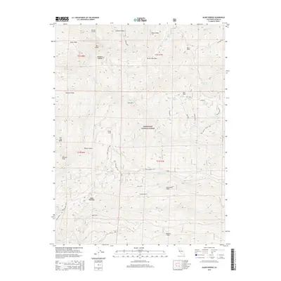
2015 Map of Alder Springs
USGS Topo · Published 2015About this map
Alder Springs and Fiddlers Green serve as central points of reference in this mid-2010s survey of the high country within the Mendocino National Forest. The landscape is defined by a series of prominent ridges, including Hardin Ridge, Skidmore Ridge, and Rattlesnake Ridge, which channel drainage into complex creek systems. Water sources are abundant but specific, with numerous named springs like Cottonwood Spring, Manzanita Spring, and Bear Wallow Spring dotting the terrain. The transport network is dominated by mountain routes such as Forest Highway Seven and Alder Springs Rd, facilitating access through the diverse elevations of the Coast Range. Small-scale water management is evident at Forks Reservoir, while the presence of locations like Grassy Patch and Salt Gulch suggests a history of local geographic naming tied to specific environmental characteristics.
Find a feature on this map
48 named features on this map. Tap any name to fly to it.
Don’t see what you’re looking for? This feature index may not catch every label — zoom into the map to look around manually.
Map Details
Editions of this 2015 Alder Springs Map
This is the sole edition of this map. No revisions or reprints were ever made.
Other maps of this area

1919 · Elk Creek
USGS Topo · 1:62,500

1948 · Elk Creek
USGS Topo · 1:62,500

1952 · Paskenta
USGS Topo · 1:62,500

1952 · Hull Mountain
USGS Topo · 1:62,500

1952 · Anthony Peak
USGS Topo · 1:62,500

1957 · Elk Creek
USGS Topo · 1:62,500

1957 · Ukiah
USGS Topo · 1:250,000

1960 · Ukiah
USGS Topo · 1:250,000
1967 · Plaskett meadows
USGS Topo · 1:24,000
1967 · Log Spring
USGS Topo · 1:24,000