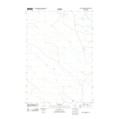
2012 Map of Alkali Creek West
USGS Topo · Published 2012About this map
The S Fork Moreau River and its network of tributaries define this Butte County landscape, where water drainage patterns reveal the subtle relief of the northern plains. The terrain is anchored by the prominent Fourmile Butte in the southern portion of the quadrangle, a landmark overlooking the winding course of Fourmile Cr. Historical transit routes are well-preserved here, with modern and legacy alignments including Co Hwy-897 and Old Co Hwy 897 tracing the high ground between watersheds. The map documents a sparsely populated ranching environment where life revolves around the seasonal flows of Alkali Cr and Cady Cr. Researchers can trace the evolution of local infrastructure through the distinct markings of Old Hwy 85, which provides a clear record of how regional connectivity has shifted over time.
Find a feature on this map
8 named features on this map. Tap any name to fly to it.
Don’t see what you’re looking for? This feature index may not catch every label — zoom into the map to look around manually.
Map Details
Editions of this 2012 Alkali Creek West Map
This is the sole edition of this map. No revisions or reprints were ever made.
Other maps of this area

1935 · Harding
USGS Topo · 1:125,000

1954 · Lemmon
USGS Topo · 1:250,000

1957 · Lemmon
USGS Topo · 1:250,000

1973 · Hells Canyon
USGS Topo · 1:24,000
1977 · Antelope Creek West
USGS Topo · 1:24,000
1977 · Greasewood Draw
USGS Topo · 1:24,000
1978 · Indian Butte
USGS Topo · 1:24,000
1978 · Alkali Creek West
USGS Topo · 1:24,000
1978 · Gustave
USGS Topo · 1:24,000
1978 · Moreau Peak
USGS Topo · 1:24,000