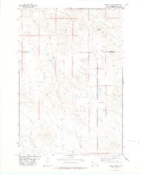
1978 Map of Indian Butte
USGS Topo · Published 1978About this map
The South Fork Moreau River cuts through the high plains of the northwestern South Dakota borderlands in this late 1970s topographic survey. The landscape is defined by its prominent landforms, notably Indian Butte in the south and Gustave Butte to the north, which serve as regional landmarks across the open terrain. This survey captures a moment of modern utility infrastructure, tracing a Pipeline that traverses the northern sections alongside several identified Drill Hole sites. The drainage pattern of the region is highly detailed, showing the convergence of North Indian Creek, Crooked Creek, and Fourmile Creek. Situated along the boundary where Harding and Butte Counties meet, the map illustrates the stark, unpopulated character of the western rangelands before significant further development occurred.
Find a feature on this map
10 named features on this map. Tap any name to fly to it.
Don’t see what you’re looking for? This feature index may not catch every label — zoom into the map to look around manually.
Map Details
Editions of this 1978 Indian Butte Map
This is the sole edition of this map. No revisions or reprints were ever made.
Other maps of this area

1935 · Harding
USGS Topo · 1:125,000

1954 · Lemmon
USGS Topo · 1:250,000

1954 · Ekalaka
USGS Topo · 1:250,000

1956 · Ekalaka
USGS Topo · 1:250,000

1957 · Lemmon
USGS Topo · 1:250,000

1958 · Ekalaka
USGS Topo · 1:250,000

1965 · Ekalaka
USGS Topo · 1:250,000

1973 · Hells Canyon
USGS Topo · 1:24,000
1977 · Greasewood Draw
USGS Topo · 1:24,000
1978 · Alkali Creek West
USGS Topo · 1:24,000