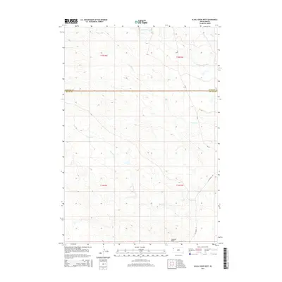
2015 Map of Alkali Creek West
USGS Topo · Published 2015About this map
S Fork Moreau River cuts across the northern landscape of this corner of South Dakota, where the prairie begins to break into the subtle drainages of the western plains. This area, straddling the Harding and Butte County line, is defined by an intricate network of intermittent waterways such as Alkali Cr, Fourmile Cr, and Cady Cr. The terrain is anchored by the prominent Fourmile Butte in the southern reaches, providing a rare vertical landmark in a region otherwise characterized by wide-open grazing land. Evidence of regional transit is visible along the eastern edge, where Old Highway 85 and CR-897 provide the primary connections through this sparsely populated ranching country.
Find a feature on this map
13 named features on this map. Tap any name to fly to it.
Don’t see what you’re looking for? This feature index may not catch every label — zoom into the map to look around manually.
Map Details
Editions of this 2015 Alkali Creek West Map
This is the sole edition of this map. No revisions or reprints were ever made.
Other maps of this area

1935 · Harding
USGS Topo · 1:125,000

1954 · Lemmon
USGS Topo · 1:250,000

1957 · Lemmon
USGS Topo · 1:250,000

1973 · Hells Canyon
USGS Topo · 1:24,000
1977 · Antelope Creek West
USGS Topo · 1:24,000
1977 · Greasewood Draw
USGS Topo · 1:24,000
1978 · Indian Butte
USGS Topo · 1:24,000
1978 · Alkali Creek West
USGS Topo · 1:24,000
1978 · Gustave
USGS Topo · 1:24,000
1978 · Moreau Peak
USGS Topo · 1:24,000