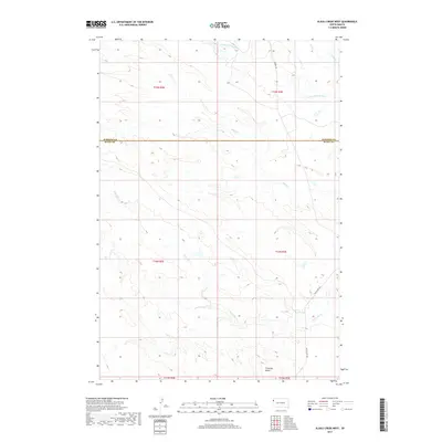
2017 Map of Alkali Creek West
USGS Topo · Published 2017About this map
S Fork Moreau River winds through the northern reaches of this high plains landscape, crossing the line between Harding and Butte counties. The terrain is defined by the drainage patterns of several seasonal watercourses, including Alkali Cr and Fourmile Cr, which carve through the open range toward the Moreau. The prominent landform of Fourmile Butte stands as a clear landmark in the southern section of the survey area, providing a vertical break in the undulating topography.
Find a feature on this map
14 named features on this map. Tap any name to fly to it.
Don’t see what you’re looking for? This feature index may not catch every label — zoom into the map to look around manually.
Map Details
Editions of this 2017 Alkali Creek West Map
This is the sole edition of this map. No revisions or reprints were ever made.
Other maps of this area

1935 · Harding
USGS Topo · 1:125,000

1954 · Lemmon
USGS Topo · 1:250,000

1957 · Lemmon
USGS Topo · 1:250,000

1973 · Hells Canyon
USGS Topo · 1:24,000
1977 · Antelope Creek West
USGS Topo · 1:24,000
1977 · Greasewood Draw
USGS Topo · 1:24,000
1978 · Indian Butte
USGS Topo · 1:24,000
1978 · Alkali Creek West
USGS Topo · 1:24,000
1978 · Gustave
USGS Topo · 1:24,000
1978 · Moreau Peak
USGS Topo · 1:24,000