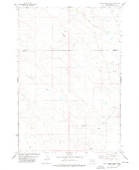
1978 Map of Alkali Creek West
USGS Topo · Published 1978About this map
The South Fork Moreau River meanders through the northern reaches of this landscape, marking a territory defined by intricate drainages and isolated landmarks. Situated along the boundary where Harding Co meets Butte Co, the terrain is characterized by long, winding waterways including Alkali Creek, Fourmile Creek, and Cady Creek. These seasonal flows have carved a complex network of draws and ridges across the High Plains, occasionally broken by prominent elevations such as Fourmile Butte and Little Butte. Evidence of resource exploration is sparse but present, noted by a lone Drill Hole located north of Alkali Creek. The map captures a moment in the late 1970s when this segment of South Dakota remained largely open range, with fine red dashed lines indicating the placement of selected fence lines and property boundaries across the cattle country.
Find a feature on this map
9 named features on this map. Tap any name to fly to it.
Don’t see what you’re looking for? This feature index may not catch every label — zoom into the map to look around manually.
Map Details
Editions of this 1978 Alkali Creek West Map
This is the sole edition of this map. No revisions or reprints were ever made.
Other maps of this area

1935 · Harding
USGS Topo · 1:125,000

1954 · Lemmon
USGS Topo · 1:250,000

1957 · Lemmon
USGS Topo · 1:250,000

1973 · Hells Canyon
USGS Topo · 1:24,000
1977 · Antelope Creek West
USGS Topo · 1:24,000
1977 · Greasewood Draw
USGS Topo · 1:24,000
1978 · Indian Butte
USGS Topo · 1:24,000
1978 · Gustave
USGS Topo · 1:24,000
1978 · Moreau Peak
USGS Topo · 1:24,000
1978 · Alkali Creek East
USGS Topo · 1:24,000