
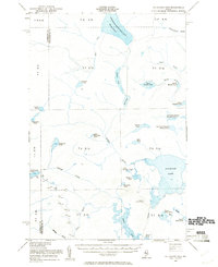
1954 Map of Allagash Lake
USGS Topo · Published 1955About this map
Allagash Lake sits at the heart of this mid-century survey, a wilderness landscape defined by an intricate network of interconnected waterways and remote ponds. This part of the North Maine Woods, straddling the Somerset Co Piscataquis Co line, reveals a terrain shaped by lumbering interests and remote management. The presence of the Allagash Lookout Tower on a high point above the lake and a simple Jeep Trail cutting across the western townships underscore the region's primary use for timber surveying and fire prevention during the 1950s. To the north, the massive Chemquasabamticook Lake (Ross Lake) drains through Sweeney Bk, while a chain of ponds—from Upper Russell Pond down to Lower Russell Pond—illustrates the complex drainage patterns of the Russell Brook watershed. This map preserves the nomenclature of a vast, unorganized territory before modern access roads altered its character.
Find a feature on this map
48 named features on this map. Tap any name to fly to it.
Don’t see what you’re looking for? This feature index may not catch every label — zoom into the map to look around manually.
Map Details
Editions of this 1954 Allagash Lake Map
2 editions found
Other maps of this area

1932 · Umsaskis Lake
USGS Topo · 1:48,000

1935 · Umsaskis Lake
USGS Topo · 1:62,500

1954 · Chesuncook
USGS Topo · 1:62,500

1954 · Baker Lake
USGS Topo · 1:62,500

1954 · Caucomgomoc Lake
USGS Topo · 1:62,500

1954 · Churchill Lake
USGS Topo · 1:62,500

1954 · St. John Pond
USGS Topo · 1:62,500

1954 · Presque Isle
USGS Topo · 1:250,000

1955 · Beaver Pond
USGS Topo · 1:62,500

1955 · Clayton Lake
USGS Topo · 1:62,500