
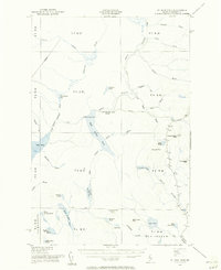
1954 Map of St. John Pond
USGS Topo · Published 1955About this map
The remote Maine backcountry of Somerset County is defined by a complex drainage network at the headwaters of the North Branch Penobscot River and its connection to the St. John River basin. This mid-century survey illustrates a landscape dominated by timber-industry access and water management, featuring St John Pond Depot as a lonely outpost near the Fifth St John Pond. A notable engineering feature is the Canal and Spillway connecting the pond systems, suggesting historically significant water diversion for log driving. The terrain rises to several named peaks, including Little Russell Mtn and Mulcalsea Mtn, each equipped with a Lookout Tower for fire spotting. The map details a series of sequential ponds, from First St John Pond through the fifth, along with expansive wetlands like Abacotnetic Bog and Big Bog.
Find a feature on this map
57 named features on this map. Tap any name to fly to it.
Don’t see what you’re looking for? This feature index may not catch every label — zoom into the map to look around manually.
Map Details
Editions of this 1954 St. John Pond Map
2 editions found
Other maps of this area

1949 · Jackman
USGS Topo · 1:250,000

1954 · Seboomook Lake
USGS Topo · 1:62,500

1954 · North East Carry
USGS Topo · 1:62,500

1954 · Baker Lake
USGS Topo · 1:62,500

1954 · Caucomgomoc Lake
USGS Topo · 1:62,500

1954 · Allagash Lake
USGS Topo · 1:62,500

1954 · Presque Isle
USGS Topo · 1:250,000

1954 · Millinocket
USGS Topo · 1:250,000

1956 · Penobscot Lake
USGS Topo · 1:62,500

1957 · Norris Brook
USGS Topo · 1:62,500