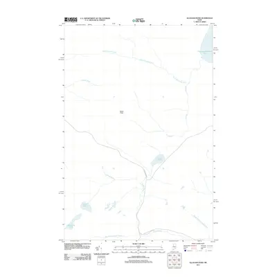
2011 Map of Allagash Pond
USGS Topo · Published 2011About this map
Allagash Stream and its various branches define this landscape in the Maine North Woods, illustrating the complex hydrography of the T9 R15 WELS region. The map documents the critical intersection of natural waterways and the industrial infrastructure necessary for timber management, most notably the Boise Cascade Rd and International Paper Rd. These logging roads provide the primary access to the interior, cutting across the drainages of Ross Inlet and Comstock Brook. The presence of large water bodies like Chemquasabamticook Lake and smaller, isolated features such as Desolation Pond and Corner Pond highlights the area's character as a working forest. High ground at Maple Ridge stands as a prominent landmark amidst the network of brooks and inlets that feed the Allagash wilderness, reflecting the geography of a territory traditionally used for commercial forestry and recreation.
Find a feature on this map
13 named features on this map. Tap any name to fly to it.
Don’t see what you’re looking for? This feature index may not catch every label — zoom into the map to look around manually.
Map Details
Editions of this 2011 Allagash Pond Map
This is the sole edition of this map. No revisions or reprints were ever made.
Other maps of this area

1954 · Baker Lake
USGS Topo · 1:62,500

1954 · Allagash Lake
USGS Topo · 1:62,500

1954 · Presque Isle
USGS Topo · 1:250,000

1955 · Beaver Pond
USGS Topo · 1:62,500

1955 · Clayton Lake
USGS Topo · 1:62,500

1958 · Presque Isle
USGS Topo · 1:250,000

1960 · Presque Isle
USGS Topo · 1:250,000

1961 · Allagash Lake
USGS Topo · 1:62,500

1962 · Baker Lake
USGS Topo · 1:62,500
1986 · Beaver Pond SE
USGS Topo · 1:24,000