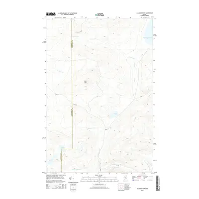
2014 Map of Allagash Pond
USGS Topo · Published 2014About this map
Allagash Pond and its surrounding watershed define this northern Maine landscape within the Allagash Wilderness region. The terrain is characterized by the prominent elevation of Maple Ridge and a dense network of waterways, including Allagash Stream and the southern reaches of Chemquasabamticook Lake. This 2014 survey documents a remote section of the North Maine Woods, where the border between Somerset Co and Piscataquis Co runs through a territory accessed primarily by unpaved timber roads like St Juste Rd and Cyr Rd. The map reveals the intricate drainage patterns of the area, from Comstock Brook in the west to the multiple branches of the Allagash Stream, illustrating the hydrological significance of this remote timberland. Significant water bodies such as Corner Pond and Desolation Pond are also noted, providing a detailed look at the geography of this managed forest environment.
Find a feature on this map
18 named features on this map. Tap any name to fly to it.
Don’t see what you’re looking for? This feature index may not catch every label — zoom into the map to look around manually.
Map Details
Editions of this 2014 Allagash Pond Map
This is the sole edition of this map. No revisions or reprints were ever made.
Other maps of this area

1954 · Baker Lake
USGS Topo · 1:62,500

1954 · Allagash Lake
USGS Topo · 1:62,500

1954 · Presque Isle
USGS Topo · 1:250,000

1955 · Beaver Pond
USGS Topo · 1:62,500

1955 · Clayton Lake
USGS Topo · 1:62,500

1958 · Presque Isle
USGS Topo · 1:250,000

1960 · Presque Isle
USGS Topo · 1:250,000

1961 · Allagash Lake
USGS Topo · 1:62,500

1962 · Baker Lake
USGS Topo · 1:62,500
1986 · Beaver Pond SE
USGS Topo · 1:24,000