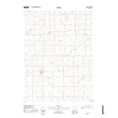
2017 Map of Allen
USGS Topo · Published 2017About this map
Allen serves as the central hub of this Springbank Township landscape, where a precise grid of county roads meets the meandering drainage of the northern Nebraska plains. This 2017 study illustrates a deeply rural environment defined by its watercourses and agricultural layout, including Rattlesnake Cr and Minnow Cr. The local geography is marked by subtle rises such as Cottonwood Hill and the presence of the Pohma Reservoir to the north. For those tracing family ties to Dixon County, the map provides the exact location of the Springbank Cem east of town. The surrounding terrain is intricately carved by numerous named streams, including Pigeon Cr, Elk Cr, and Otter Cr, which dictate the placement of farms and section lines throughout Townships 28 and 29 North.
Find a feature on this map
40 named features on this map. Tap any name to fly to it.
Don’t see what you’re looking for? This feature index may not catch every label — zoom into the map to look around manually.
Map Details
Editions of this 2017 Allen Map
This is the sole edition of this map. No revisions or reprints were ever made.
Other maps of this area

1898 · Elk Point
USGS Topo · 1:125,000

1901 · Elk Point
USGS Topo · 1:125,000

1907 · Elk Point
USGS Topo · 1:125,000

1955 · Sioux City
USGS Topo · 1:250,000

1958 · Sioux City
USGS Topo · 1:250,000

1959 · Sioux City
USGS Topo · 1:250,000

1964 · Martinsburg SW
USGS Topo · 1:24,000
1964 · Ponca
USGS Topo · 1:24,000
1964 · Martinsburg
USGS Topo · 1:24,000

1967 · Waterbury
USGS Topo · 1:24,000