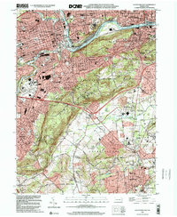
1999 Map of Allentown East
USGS Topo · Published 2001About this map
The Lehigh River corridor serves as the industrial and topographic spine of this region, separating the dense urban grids of Allentown and Bethlehem. At the turn of the millennium, the landscape reveals a complex layering of legacy infrastructure and modern expansion. The Lehigh Canal and Conrail lines trace the riverbanks, reflecting the valley's historic transport heritage, while the steep slopes of South Mountain and Lehigh Mountain provide a natural buffer between the cities and the suburbanizing valley to the south.
Find a feature on this map
78 named features on this map. Tap any name to fly to it.
Don’t see what you’re looking for? This feature index may not catch every label — zoom into the map to look around manually.
Map Details
Editions of this 1999 Allentown East Map
This is the sole edition of this map. No revisions or reprints were ever made.
Other maps of this area

1888 · Quakertown
USGS Topo · 1:62,500

1890 · Quakertown
USGS Topo · 1:62,500

1894 · Allentown
USGS Topo · 1:62,500

1894 · Quakertown
USGS Topo · 1:62,500

1902 · Boyertown
USGS Topo · 1:62,500

1902 · Slatington
USGS Topo · 1:62,500

1937 · Allentown West
USGS Topo · 1:48,000

1939 · Allentown
USGS Topo · 1:62,500

1942 · Norristown
USGS Topo · 1:125,000

1942 · Allentown West
USGS Topo · 1:62,500