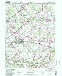
1995 Map of Allentown
USGS Topo · Published 1999About this map
Allentown serves as a central hub on this Monmouth County landscape, where the waters of Doctors Creek flow toward Conines Millpond. The late 20th-century topography reveals a mix of preserved open spaces and transportation corridors, most notably the Assunpink Wildlife Management Area and the path of the New Jersey Turnpike. Smaller agricultural and milling outposts like Carsons Mills, Kirbys Mills, and Walnford reflect the region's long-standing rural character, while the Old Railroad Grade north of Eilers Corner points to earlier eras of transit. To the west, the Trenton-Robbinsville Airport and Robbinsville highlight the increasing modernization of the area near the Mercer County line. From the quiet shores of Imlaystown Lake to the clusters of homes at Cream Ridge and Nelsonville, the map provides a clear picture of the diverse settlement patterns in the Upper Freehold and Washington townships during the 1990s.
Find a feature on this map
53 named features on this map. Tap any name to fly to it.
Don’t see what you’re looking for? This feature index may not catch every label — zoom into the map to look around manually.
Map Details
Editions of this 1995 Allentown Map
This is the sole edition of this map. No revisions or reprints were ever made.
Other maps of this area

1888 · Bordentown
USGS Topo · 1:62,500

1888 · New Brunswick
USGS Topo · 1:62,500

1888 · Princeton
USGS Topo · 1:62,500

1888 · Cassville
USGS Topo · 1:62,500

1893 · Bordentown
USGS Topo · 1:62,500

1893 · New Brunswick
USGS Topo · 1:62,500

1894 · Princeton
USGS Topo · 1:62,500

1894 · Cassville
USGS Topo · 1:62,500

1900 · Cassville
USGS Topo · 1:62,500

1901 · New Brunswick
USGS Topo · 1:62,500
Featured Places
- Hamilton Township, NJ
- East Windsor Township, NJ
- West Windsor, NJ
- Robbinsville Township, NJ
- Millstone Township, NJ