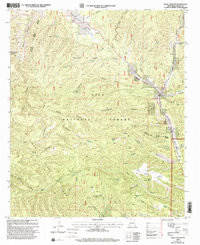
1999 Map of Allie Canyon
USGS Topo · Published 2002About this map
The Pinos Altos Range dominates this portion of the Gila National Forest, where the complex drainage systems of Allie Canyon and Bear Canyon descend toward the Mimbres River valley. This 1990s survey captures a landscape of managed wilderness and ranching history, centered around the Gila Wilderness Ranger Station and the established GOS Ranch near the confluence of Sapillo Creek. The presence of several named water sources, including Soldier Spring, Grave Spring, and Little Bear Spring, indicates the critical importance of water management in this arid environment for both livestock and forest service operations. Traces of older transport networks remain visible, most notably the Wood Haul Wagon Road Trail, which reflects the early industrial and domestic wood-cutting needs of the surrounding Grant County communities. Along the eastern edge, the river valley provides a corridor for small-scale development, including a mobile home park and the Hicks Cem.
Find a feature on this map
64 named features on this map. Tap any name to fly to it.
Don’t see what you’re looking for? This feature index may not catch every label — zoom into the map to look around manually.
Map Details
Editions of this 1999 Allie Canyon Map
This is the sole edition of this map. No revisions or reprints were ever made.
Other maps of this area

1909 · Silver City
USGS Topo · 1:125,000

1911 · Alum Mountain
USGS Topo · 1:125,000

1913 · Alum Mountain
USGS Topo · 1:125,000

1937 · Santa Rita
USGS Topo · 1:24,000

1947 · Allie Canyon
USGS Topo · 1:24,000

1947 · Twin Sisters
USGS Topo · 1:24,000

1947 · Fort Bayard
USGS Topo · 1:24,000

1948 · Twin Sisters
USGS Topo · 1:24,000

1948 · Santa Rita
USGS Topo · 1:24,000

1948 · Allie Canyon
USGS Topo · 1:24,000