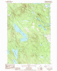
1987 Map of Alligator Lake
USGS Topo · Published 1988About this map
Alligator Lake dominates this inland landscape of Hancock County, surrounded by a complex system of glacial ponds and narrow ridges. The terrain transitions from the elevations of Eagle Mountain and Blackcap Mtn down into the wetlands of Humpback Bog and the watercourse of the Narraguagus R. This 1980s-era survey reveals the geographic division of unorganized territories such as T 34 M D and T 28 M D, alongside the boundaries of Aurora and Great Plantation No 33. Numerous family-named landmarks like John Brown Brook, Lovejoy Pond, and Jimmies Mtn suggest a history of local land use even in this predominantly wooded and aquatic region. The map preserves the network of unimproved roads and trails that linked these remote water bodies before late-20th-century developments altered the character of the Maine woods.
Find a feature on this map
36 named features on this map. Tap any name to fly to it.
Don’t see what you’re looking for? This feature index may not catch every label — zoom into the map to look around manually.
Map Details
Editions of this 1987 Alligator Lake Map
This is the sole edition of this map. No revisions or reprints were ever made.
Other maps of this area

1929 · Great Pond
USGS Topo · 1:48,000

1929 · Lead Mountain
USGS Topo · 1:48,000

1931 · Saponac
USGS Topo · 1:48,000

1932 · Nicatous Lake
USGS Topo · 1:48,000

1932 · Lead Mountain
USGS Topo · 1:62,500

1932 · Great Pond
USGS Topo · 1:62,500

1934 · Saponac
USGS Topo · 1:62,500

1934 · Nicatous Lake
USGS Topo · 1:62,500

1948 · Bangor
USGS Topo · 1:250,000

1954 · Millinocket
USGS Topo · 1:250,000