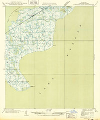
1949 Map of Alligator Point
USGS Topo · Published 1949About this map
The coastal marshlands of Orleans Parish are defined by an intricate network of waterways where the Louisville and Nashville railroad cuts a straight path across the wetlands. This mid-century survey captures the landscape as it appeared in the late 1940s, shortly after the era of the Board of State Engineers. The rail line serves as the primary terrestrial artery, crossing over Unknown Pass and skirting the edge of Lake Catherine. To the south and east, the land dissolves into the expanse of Lake Borgne, punctuated by points such as Shell Pt and Alligator Pt.
Find a feature on this map
18 named features on this map. Tap any name to fly to it.
Don’t see what you’re looking for? This feature index may not catch every label — zoom into the map to look around manually.
Map Details
Editions of this 1949 Alligator Point Map
This is the sole edition of this map. No revisions or reprints were ever made.
Other maps of this area

1892 · Chef Menteur
USGS Topo · 1:62,500

1892 · St. Bernard
USGS Topo · 1:62,500

1893 · Rigolets
USGS Topo · 1:62,500

1893 · Shell Beach
USGS Topo · 1:62,500

1935 · English Lookout
USGS Topo · 1:31,680

1936 · North Shore
USGS Topo · 1:31,680

1936 · Chef Menteur
USGS Topo · 1:62,500

1936 · Rigolets
USGS Topo · 1:62,500

1937 · Chef Menteur
USGS Topo · 1:31,680

1939 · Shell Beach
USGS Topo · 1:62,500