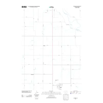
2013 Map of Allison
USGS Topo · Published 2013About this map
Allison serves as the primary hub in this portion of Butler County, oriented around a grid of numbered streets just south of the Allison Municipal Airport. The landscape is defined by the subtle drainage patterns of the eastern Iowa plains, where the Shell Rock River and its numerous tributaries, including Coldwater Cr and Palmer Cr, dictate the local topography. This early 21st-century survey illustrates the persistent agricultural grid, with long straight stretches of Ivy Ave and Keystone Ave segmenting the countryside between small rural clusters like Wilmar and Pilot Rock. The map details a transition point where smaller watercourses like Kilson Cr and Dailey Cr feed into the regional drainage network, reflecting the area's deep-rooted connection to its waterways and fertile terrain.
Find a feature on this map
44 named features on this map. Tap any name to fly to it.
Don’t see what you’re looking for? This feature index may not catch every label — zoom into the map to look around manually.
Map Details
Editions of this 2013 Allison Map
This is the sole edition of this map. No revisions or reprints were ever made.
Other maps of this area

1954 · Waterloo
USGS Topo · 1:250,000

1955 · Waterloo
USGS Topo · 1:250,000

1971 · Coster
USGS Topo · 1:24,000

1971 · Nashua NW
USGS Topo · 1:24,000

1971 · Clarksville
USGS Topo · 1:24,000

1972 · Dumont North
USGS Topo · 1:24,000
1972 · Aureola
USGS Topo · 1:24,000

1972 · Allison
USGS Topo · 1:24,000
1972 · Greene
USGS Topo · 1:24,000

1979 · Dumont South
USGS Topo · 1:24,000