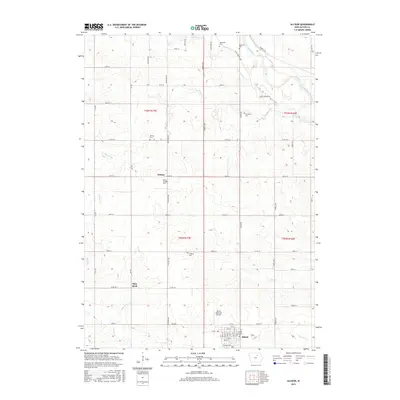
2015 Map of Allison
USGS Topo · Published 2015About this map
The town of Allison serves as a focal point in this Butler County landscape, characterized by a grid of rural roads and the meandering path of the Shell Rock River in the northeast. This 2015 study provides a clear view of the agricultural and civic organization of the region, anchored by the Allison Municipal Airport and the small settlement of Wilmar. Genealogists will find significant value in the distribution of family and community burial sites scattered throughout the townships, including Hardemen Cem, Brethren Cem, and Nettleton Cem near the river, as well as Wilmar Cem, South Wilmar Cem, and Jungling Cem further south. The terrain is marked by distinctive local landmarks like Pilot Rock and a network of named waterways such as Coldwater Cr, Palmer Cr, and McClure Cr, which have shaped the drainage and land use patterns of the surrounding prairie.
Find a feature on this map
62 named features on this map. Tap any name to fly to it.
Don’t see what you’re looking for? This feature index may not catch every label — zoom into the map to look around manually.
Map Details
Editions of this 2015 Allison Map
This is the sole edition of this map. No revisions or reprints were ever made.
Other maps of this area

1954 · Waterloo
USGS Topo · 1:250,000

1955 · Waterloo
USGS Topo · 1:250,000

1971 · Coster
USGS Topo · 1:24,000

1971 · Nashua NW
USGS Topo · 1:24,000

1971 · Clarksville
USGS Topo · 1:24,000

1972 · Dumont North
USGS Topo · 1:24,000
1972 · Aureola
USGS Topo · 1:24,000

1972 · Allison
USGS Topo · 1:24,000
1972 · Greene
USGS Topo · 1:24,000

1979 · Dumont South
USGS Topo · 1:24,000