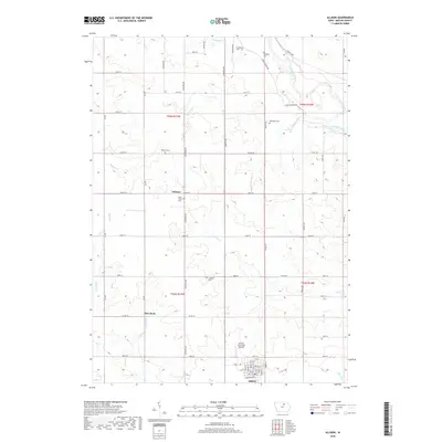
2018 Map of Allison
USGS Topo · Published 2018About this map
Allison sits at the southern edge of this Butler County landscape, serving as a hub where grid-patterned streets like 7th St and 10th St meet the Allison Municipal Airport. The surrounding terrain is defined by the winding course of the Shell Rock River in the northeast and a network of agricultural sections connected by an extensive system of avenues and streets. Local heritage is preserved in numerous rural burial grounds, including Hardeman Cem, Nettleton Cem, and the Brethren Cem near the riverbanks. The small settlement of Wilmar and the landmark known as Pilot Rock stand as notable points of reference in a landscape otherwise dominated by the drainages of Palmer Cr, Kilson Cr, and Dailey Cr. This modern survey illustrates the enduring township-and-range layout that has organized Iowa’s farmland for generations.
Find a feature on this map
64 named features on this map. Tap any name to fly to it.
Don’t see what you’re looking for? This feature index may not catch every label — zoom into the map to look around manually.
Map Details
Editions of this 2018 Allison Map
This is the sole edition of this map. No revisions or reprints were ever made.
Other maps of this area

1954 · Waterloo
USGS Topo · 1:250,000

1955 · Waterloo
USGS Topo · 1:250,000

1971 · Coster
USGS Topo · 1:24,000

1971 · Nashua NW
USGS Topo · 1:24,000

1971 · Clarksville
USGS Topo · 1:24,000

1972 · Dumont North
USGS Topo · 1:24,000
1972 · Aureola
USGS Topo · 1:24,000

1972 · Allison
USGS Topo · 1:24,000
1972 · Greene
USGS Topo · 1:24,000

1979 · Dumont South
USGS Topo · 1:24,000