1938 Map of Allyn
USGS Topo · Published 1965About this map
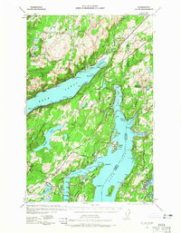
The waters of Hood Canal and Case Inlet define this landscape on the Kitsap Peninsula as it appeared in the late 1930s. Coastal settlements like Allyn and Grapeview serve as focal points along the shoreline, while the interior is dotted with numerous small bodies of water including Lake Spencer and Lake Wooten. The map reveals a specialized maritime and recreational geography, featuring Twanoh State Park and the distinct forms of Hartstene Island, Stretch Island, and Reach Island. Transport depends on early routes like State Hwy 14 and the Dewatto Bay Road, which connect the scattered communities of Belfair, Home, and Vaughn. Rural infrastructure is further evidenced by the Grant Sch and a series of survey benchmarks, reflecting a period of systematic mapping and coastal development by the Army Corps of Engineers.
Find a feature on this map
67 named features on this map. Tap any name to fly to it.
Don’t see what you’re looking for? This feature index may not catch every label — zoom into the map to look around manually.
Map Details
Editions of this 1938 Allyn Map
2 editions found

Historical Maps of Bremerton Through Time
1 maps found