2023 Map of Altamont
USGS Topo · Published 2023About this map
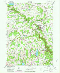
The village of Altamont sits at the foot of the Helderberg Mountains, where the elevation rises sharply from the Hudson Valley floor. This landscape is defined by the steep escarpment and the drainage of the Bozen Kill, which features the notable Bozen Kill Falls to the northwest. For genealogists and local historians, the area is rich with family-named landmarks and small burial grounds including Severson Cem, Lainhart Cem, and Ostrander Cem, many of which are tucked away along older rural routes like Settles Hill Rd. To the west, the settlements of Knox and East Township overlook the Altamont Reservoir, while recreational and natural hubs at Thompsons Lake and Warners Lake anchor the southern reaches of the map. The rugged terrain of Indian Ladder and Horseshoe Lot illustrates the geologically significant cliffs that have long shaped the region's development and transport networks.
Find a feature on this map
84 named features on this map. Tap any name to fly to it.
Don’t see what you’re looking for? This feature index may not catch every label — zoom into the map to look around manually.
Map Details
Editions of this 2023 Altamont Map
This is the sole edition of this map. No revisions or reprints were ever made.
Historical Maps of Princetown Through Time
3 maps found