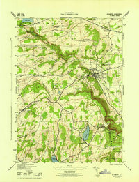
1946 Map of Altamont
USGS Topo · Published 1946About this map
Altamont serves as a focal point at the base of the dramatic Escarpment, where the Delaware and Hudson RR curves through the village near the Fairgrounds and Union Sch. The landscape is defined by the sharp rise of the Helderberg Mtns, home to the sprawling John Boyd Thacher State Park. This area is rich in geological and recreational landmarks, including the celebrated Indian Ladder, Haile Cave, and Mine Lot Falls.
Find a feature on this map
47 named features on this map. Tap any name to fly to it.
Don’t see what you’re looking for? This feature index may not catch every label — zoom into the map to look around manually.
Map Details
Editions of this 1946 Altamont Map
This is the sole edition of this map. No revisions or reprints were ever made.
Other maps of this area

1893 · Schenectady
USGS Topo · 1:62,500

1893 · Albany
USGS Topo · 1:62,500

1895 · Albany
USGS Topo · 1:62,500

1895 · Schenectady
USGS Topo · 1:62,500

1895 · Amsterdam
USGS Topo · 1:62,500

1898 · Schenectady
USGS Topo · 1:62,500

1898 · Albany
USGS Topo · 1:62,500

1900 · Berne
USGS Topo · 1:62,500

1903 · Berne
USGS Topo · 1:62,500

1927 · Albany
USGS Topo · 1:62,500