2023 Map of Alton
USGS Topo · Published 2023About this map
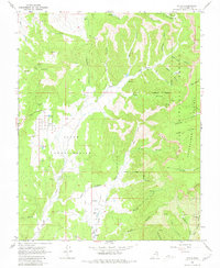
Alton serves as the primary settlement on this landscape, situated at the edge of the Dixie National Forest. The town's grid is clearly defined by Main St and Second North St, with the Alton Cem located on the western periphery. Genealogists will find particular interest in the outlying Roundy Cem and the Roundy / Johnson Cem nestled near Roundy Canyon. The terrain is characterized by the dramatic transition from the high Paunsaugunt Plateau down to the Pink Cliffs and Sunset Cliffs. The mapping reveals a complex network of drainage systems, including Kanab Creek and Minnie Creek, which have carved numerous named canyons such as Birch Canyon and Robinson Canyon. The presence of the Alton Amphitheater and recreation routes like the Paunsaugunt Atv Trl indicate the area's integration of local community life with the surrounding wilderness and natural landmarks.
Find a feature on this map
45 named features on this map. Tap any name to fly to it.
Don’t see what you’re looking for? This feature index may not catch every label — zoom into the map to look around manually.
Map Details
Editions of this 2023 Alton Map
This is the sole edition of this map. No revisions or reprints were ever made.